Stony Hill geodata
Stony Hill (St. Andrew) is a populated place; located in Jamaica in America/Jamaica (GMT-5) time zone. With population of 8,551 people, there are 19 cities with bigger population in this country. Compared to other cities in Jamaica, 57.1% of cities are located further ↑North; 80.2% of cities are located further ←West and 85.7% of cities have lower elevation than Stony Hill. Note1


Stony Hill GPS coordinates[2]
18° 4' 44.976" North, 76° 47' 5.028" West
| Map corner | latitude | longitude |
|---|---|---|
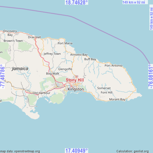
| Upper-left | 18.74628°, | -77.48786° |
| Center: | 18.07916°, | -76.78473° |
| Lower-right: | 17.40949°, | -76.08161° |
| Map W x H: | 148.6×148.6 km | = 92.3×92.3mi |
| max Lat: | 18.49358° ⇑57.1% North |
| Stony Hill: | 18.07916° |
| min Lat: | ⇓42.9% South 17.774° |
| min Long | Stony Hill | max Long |
| -78.3481° | -76.78473° | -76.24864° |
| W 80.2%⇐ | ⇒19.8% E |
Elevation
Elevation of Stony Hill is 544 m = 1785 ft, and this is 329.6 m = 1081 ft above average elevation for this country.
| Max E: |
944 m = 3097 ft | 14.3% |
| Stony Hill | 544 m 1785 ft | |
| Avg. | 214.4 m = 703 ft | |
Min E: |
1 m = 3 ft | 85.7% |
See also: Jamaica elevation on elevation.city.
Geographical zone
Stony Hill is located in North Torrid zone (between Equator and Tropic of Cancer). Distance of this Northern Tropic circle is 595.7 km =370.2 mi to North.| Distance of | km | miles | from Stony Hill |
|---|---|---|---|
| North Pole | 7996.8 | 4969 | to North |
| Arctic Circle | 5391 | 3349.8 | to North |
| Tropic Cancer | 595.7 | 370.2 | to North |
| Equator | 2010.2 | 1249.1 | to South |


Nearby cities:
15 places around Stony Hill: (largest is in red/bold)
• Annotto Bay
21.5 km =13.4 mi,  5°
5°
• Bog Walk
23.5 km =14.6 mi,  276°
276°
• Buff Bay
21.5 km =13.4 mi,  37°
37°
• Constant Spring
3.3 km =2.1 mi,  196°
196°
• Gordon Town
8.6 km =5.3 mi,  124°
124°
• Half Way Tree
7.6 km =4.7 mi,  191°
191°
• Kingston
9.2 km =5.7 mi, 185°
• Mavis Bank
13.5 km =8.4 mi,  112°
112°
• Mona Heights
8.1 km =5 mi,  154°
154°
• New Kingston
8 km =5 mi,  178°
178°
• Port Royal
16.8 km =10.4 mi, 200°
• Portmore
17.6 km =10.9 mi,  215°
215°
• Richmond
22.4 km =13.9 mi,  330°
330°
• Riversdale
21.3 km =13.2 mi,  296°
296°
• Spanish Town
20.7 km =12.9 mi,  241°
241°
Sources, notices
• [Note1] Compared only with cities in Jamaica existing in our database
• [Src1] Map data: © OpenStreetMap contributors (CC-BY-SA)
• [Src2] Other city data from geonames.org with taken over terms of usage.
• [Src3] Geographical zone / Annual Mean Temperature by Robert A. Rohde @ Wikipedia
