Lucea geodata
Lucea (Hanover) is a seat of a first-order administrative division; located in Jamaica in America/Jamaica (GMT-5) time zone. With population of 6,289 people, there are 27 cities with bigger population in this country. Compared to other cities in Jamaica, 94.5% of cities are located further ↓South; 98.9% of cities are located further →East and 89% of cities have higher elevation than Lucea. Note1


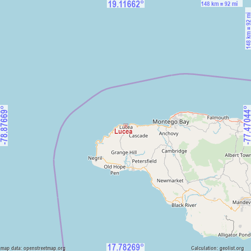
Lucea GPS coordinates[2]
18° 27' 3.42" North, 78° 10' 24.816" West
| Map corner | latitude | longitude |
|---|---|---|
| Upper-left | 19.11662°, | -78.87669° |
| Center: | 18.45095°, | -78.17356° |
| Lower-right: | 17.78269°, | -77.47044° |
| Map W x H: | 148.3×148.3 km | = 92.1×92.1mi |
| max Lat: | 18.49358° ⇑5.5% North |
| Lucea: | 18.45095° |
| min Lat: | ⇓94.5% South 17.774° |
| min Long | Lucea | max Long |
| -78.3481° | -78.17356° | -76.24864° |
| W 1.1%⇐ | ⇒98.9% E |
Elevation
Elevation of Lucea is 12 m = 39 ft, and this is 202.4 m = 664 ft below average elevation for this country.
| Max E: |
944 m = 3097 ft | 89% |
| Avg. | 214.4 m = 703 ft | |
| Lucea | 12 m = 39 ft | |
Min E: |
1 m = 3 ft | 11% |
See also: Jamaica elevation on elevation.city.
Geographical zone
Lucea is located in North Torrid zone (between Equator and Tropic of Cancer). Distance of this Northern Tropic circle is 554.4 km =344.5 mi to North.| Distance of | km | miles | from Lucea |
|---|---|---|---|
| North Pole | 7955.5 | 4943.3 | to North |
| Arctic Circle | 5349.6 | 3324.1 | to North |
| Tropic Cancer | 554.4 | 344.5 | to North |
| Equator | 2051.6 | 1274.8 | to South |


Nearby cities:
15 places around Lucea: (largest is in red/bold)
• Anchovy
25.9 km =16.1 mi,  100°
100°
• Bethel Town
29.2 km =18.1 mi,  126°
126°
• Bluefields
35.3 km =21.9 mi,  153°
153°
• Cambridge
32.4 km =20.1 mi,  118°
118°
• Cascade
9.5 km =5.9 mi, 128°
• Darliston
31.6 km =19.6 mi,  138°
138°
• Frome
17.6 km =10.9 mi,  173°
173°
• Maroon Town
41.6 km =25.8 mi,  106°
106°
• Montego Bay
27 km =16.8 mi,  85°
85°
• Mt Peto
17.3 km =10.7 mi, 124°
• Negril
27.4 km =17 mi,  222°
222°
• Petersfield
23.7 km =14.7 mi, 152°
• Sandy Bay
10.6 km =6.6 mi, 91°
• Savanna-la-Mar
26.1 km =16.2 mi, 170°
• Wakefield
47.8 km =29.7 mi, 95°
Sources, notices
• [Note1] Compared only with cities in Jamaica existing in our database
• [Src1] Map data: © OpenStreetMap contributors (CC-BY-SA)
• [Src2] Other city data from geonames.org with taken over terms of usage.
• [Src3] Geographical zone / Annual Mean Temperature by Robert A. Rohde @ Wikipedia
