Maroon Town geodata
Maroon Town (St. James) is a populated place; located in Jamaica in America/Jamaica (GMT-5) time zone. With population of 3,085 people, there are 51 cities with bigger population in this country. Compared to other cities in Jamaica, 82.4% of cities are located further ↓South; 83.5% of cities are located further →East and 82.4% of cities have lower elevation than Maroon Town. Note1


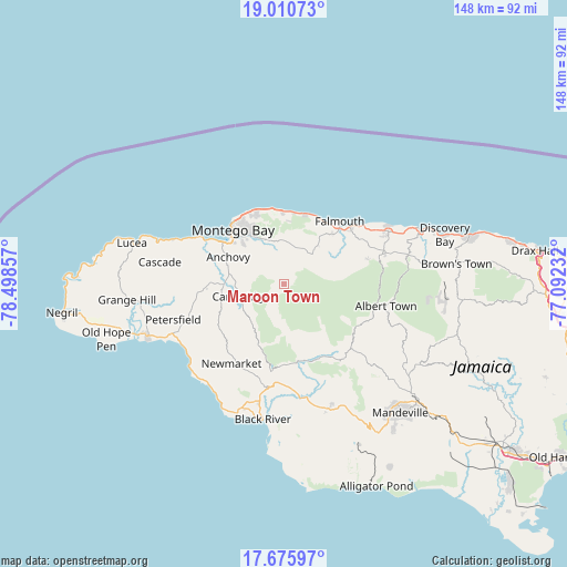
Maroon Town GPS coordinates[2]
18° 20' 40.704" North, 77° 47' 43.584" West
| Map corner | latitude | longitude |
|---|---|---|
| Upper-left | 19.01073°, | -78.49857° |
| Center: | 18.34464°, | -77.79544° |
| Lower-right: | 17.67597°, | -77.09232° |
| Map W x H: | 148.4×148.4 km | = 92.2×92.2mi |
| max Lat: | 18.49358° ⇑17.6% North |
| Maroon Town: | 18.34464° |
| min Lat: | ⇓82.4% South 17.774° |
| min Long | Maroon Town | max Long |
| -78.3481° | -77.79544° | -76.24864° |
| W 16.5%⇐ | ⇒83.5% E |
Elevation
Elevation of Maroon Town is 441 m = 1447 ft, and this is 226.6 m = 743 ft above average elevation for this country.
| Max E: |
944 m = 3097 ft | 17.6% |
| Maroon Town | 441 m 1447 ft | |
| Avg. | 214.4 m = 703 ft | |
Min E: |
1 m = 3 ft | 82.4% |
See also: Jamaica elevation on elevation.city.
Geographical zone
Maroon Town is located in North Torrid zone (between Equator and Tropic of Cancer). Distance of this Northern Tropic circle is 566.2 km =351.8 mi to North.| Distance of | km | miles | from Maroon Town |
|---|---|---|---|
| North Pole | 7967.3 | 4950.6 | to North |
| Arctic Circle | 5361.4 | 3331.4 | to North |
| Tropic Cancer | 566.2 | 351.8 | to North |
| Equator | 2039.7 | 1267.4 | to South |


Nearby cities:
15 places around Maroon Town: (largest is in red/bold)
• Albert Town
27.3 km =17 mi,  101°
101°
• Anchovy
16.1 km =10 mi,  296°
296°
• Balaclava
25 km =15.5 mi,  140°
140°
• Bethel Town
17.3 km =10.7 mi,  251°
251°
• Cambridge
11.8 km =7.3 mi, 252°
• Darliston
22.5 km =14 mi,  237°
237°
• Falmouth
22.2 km =13.8 mi,  41°
41°
• Maggotty
20.7 km =12.9 mi,  170°
170°
• Montego Bay
19.2 km =11.9 mi,  317°
317°
• Mt Peto
25.6 km =15.9 mi,  274°
274°
• Quickstep
18.2 km =11.3 mi,  120°
120°
• Rock Spring
26.1 km =16.2 mi, 100°
• Siloah
22 km =13.7 mi,  153°
153°
• Ulster Spring
29.2 km =18.1 mi, 96°
• Wakefield
10.8 km =6.7 mi,  45°
45°
Sources, notices
• [Note1] Compared only with cities in Jamaica existing in our database
• [Src1] Map data: © OpenStreetMap contributors (CC-BY-SA)
• [Src2] Other city data from geonames.org with taken over terms of usage.
• [Src3] Geographical zone / Annual Mean Temperature by Robert A. Rohde @ Wikipedia
