Cambridge geodata
Cambridge (St. James) is a populated place; located in Jamaica in America/Jamaica (GMT-5) time zone. With population of 3,930 people, there are 40 cities with bigger population in this country. Compared to other cities in Jamaica, 79.1% of cities are located further ↓South; 85.7% of cities are located further →East and 59.3% of cities have lower elevation than Cambridge. Note1


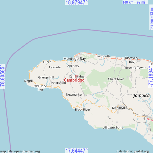
Cambridge GPS coordinates[2]
18° 18' 47.736" North, 77° 54' 9.072" West
| Map corner | latitude | longitude |
|---|---|---|
| Upper-left | 18.97947°, | -78.60565° |
| Center: | 18.31326°, | -77.90252° |
| Lower-right: | 17.64447°, | -77.1994° |
| Map W x H: | 148.4×148.4 km | = 92.2×92.2mi |
| max Lat: | 18.49358° ⇑20.9% North |
| Cambridge: | 18.31326° |
| min Lat: | ⇓79.1% South 17.774° |
| min Long | Cambridge | max Long |
| -78.3481° | -77.90252° | -76.24864° |
| W 14.3%⇐ | ⇒85.7% E |
Elevation
Elevation of Cambridge is 181 m = 594 ft, and this is 33.4 m = 110 ft below average elevation for this country.
| Max E: |
944 m = 3097 ft | 40.7% |
| Avg. | 214.4 m = 703 ft | |
| Cambridge | 181 m = 594 ft | |
Min E: |
1 m = 3 ft | 59.3% |
See also: Jamaica elevation on elevation.city.
Geographical zone
Cambridge is located in North Torrid zone (between Equator and Tropic of Cancer). Distance of this Northern Tropic circle is 569.7 km =354 mi to North.| Distance of | km | miles | from Cambridge |
|---|---|---|---|
| North Pole | 7970.8 | 4952.8 | to North |
| Arctic Circle | 5364.9 | 3333.6 | to North |
| Tropic Cancer | 569.7 | 354 | to North |
| Equator | 2036.2 | 1265.2 | to South |


Nearby cities:
15 places around Cambridge: (largest is in red/bold)
• Anchovy
11.2 km =7 mi,  344°
344°
• Bethel Town
5.5 km =3.4 mi,  248°
248°
• Bluefields
21 km =13 mi,  218°
218°
• Cascade
23.2 km =14.4 mi,  293°
293°
• Darliston
11.5 km =7.1 mi, 222°
• Frome
26.7 km =16.6 mi,  265°
265°
• Maggotty
22.4 km =13.9 mi,  139°
139°
• Maroon Town
11.8 km =7.3 mi,  72°
72°
• Montego Bay
17.6 km =10.9 mi,  354°
354°
• Mt Peto
15.3 km =9.5 mi, 291°
• Petersfield
18.7 km =11.6 mi, 252°
• Sandy Bay
23.5 km =14.6 mi,  309°
309°
• Savanna-la-Mar
26.5 km =16.5 mi, 246°
• Siloah
26.6 km =16.5 mi,  127°
127°
• Wakefield
22 km =13.7 mi,  60°
60°
Sources, notices
• [Note1] Compared only with cities in Jamaica existing in our database
• [Src1] Map data: © OpenStreetMap contributors (CC-BY-SA)
• [Src2] Other city data from geonames.org with taken over terms of usage.
• [Src3] Geographical zone / Annual Mean Temperature by Robert A. Rohde @ Wikipedia
