Bethel Town geodata
Bethel Town (Westmoreland) is a populated place; located in Jamaica in America/Jamaica (GMT-5) time zone. With population of 3,053 people, there are 53 cities with bigger population in this country. Compared to other cities in Jamaica, 73.6% of cities are located further ↓South; 89% of cities are located further →East and 72.5% of cities have lower elevation than Bethel Town. Note1


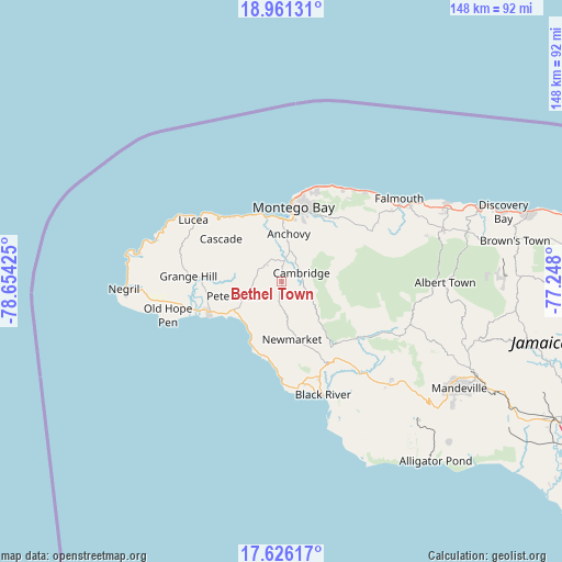
Bethel Town GPS coordinates[2]
18° 17' 42.108" North, 77° 57' 4.032" West
| Map corner | latitude | longitude |
|---|---|---|
| Upper-left | 18.96131°, | -78.65425° |
| Center: | 18.29503°, | -77.95112° |
| Lower-right: | 17.62617°, | -77.248° |
| Map W x H: | 148.5×148.5 km | = 92.3×92.3mi |
| max Lat: | 18.49358° ⇑26.4% North |
| Bethel Town: | 18.29503° |
| min Lat: | ⇓73.6% South 17.774° |
| min Long | Bethel Town | max Long |
| -78.3481° | -77.95112° | -76.24864° |
| W 11%⇐ | ⇒89% E |
Elevation
Elevation of Bethel Town is 292 m = 958 ft, and this is 77.6 m = 255 ft above average elevation for this country.
| Max E: |
944 m = 3097 ft | 27.5% |
| Bethel Town | 292 m 958 ft | |
| Avg. | 214.4 m = 703 ft | |
Min E: |
1 m = 3 ft | 72.5% |
See also: Jamaica elevation on elevation.city.
Geographical zone
Bethel Town is located in North Torrid zone (between Equator and Tropic of Cancer). Distance of this Northern Tropic circle is 571.7 km =355.2 mi to North.| Distance of | km | miles | from Bethel Town |
|---|---|---|---|
| North Pole | 7972.8 | 4954.1 | to North |
| Arctic Circle | 5367 | 3334.9 | to North |
| Tropic Cancer | 571.7 | 355.2 | to North |
| Equator | 2034.2 | 1264 | to South |


Nearby cities:
15 places around Bethel Town: (largest is in red/bold)
• Anchovy
13 km =8.1 mi,  9°
9°
• Bluefields
16.4 km =10.2 mi,  209°
209°
• Cambridge
5.5 km =3.4 mi,  68°
68°
• Cascade
19.7 km =12.2 mi,  305°
305°
• Darliston
6.9 km =4.3 mi,  202°
202°
• Frome
21.5 km =13.4 mi,  269°
269°
• Lucea
29.2 km =18.1 mi, 306°
• Maggotty
24.8 km =15.4 mi,  127°
127°
• Maroon Town
17.3 km =10.7 mi, 71°
• Montego Bay
19.9 km =12.4 mi, 9°
• Mt Peto
11.9 km =7.4 mi, 309°
• Petersfield
13.2 km =8.2 mi,  253°
253°
• Sandy Bay
21.4 km =13.3 mi,  322°
322°
• Savanna-la-Mar
21 km =13 mi, 246°
• Wakefield
27.5 km =17.1 mi,  61°
61°
Sources, notices
• [Note1] Compared only with cities in Jamaica existing in our database
• [Src1] Map data: © OpenStreetMap contributors (CC-BY-SA)
• [Src2] Other city data from geonames.org with taken over terms of usage.
• [Src3] Geographical zone / Annual Mean Temperature by Robert A. Rohde @ Wikipedia
