Wakefield geodata
Wakefield (Trelawny) is a populated place; located in Jamaica in America/Jamaica (GMT-5) time zone. With population of 2,763 people, there are 62 cities with bigger population in this country. Compared to other cities in Jamaica, 91.2% of cities are located further ↓South; 80.2% of cities are located further →East and 53.8% of cities have higher elevation than Wakefield. Note1


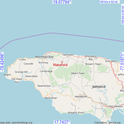
Wakefield GPS coordinates[2]
18° 24' 43.596" North, 77° 43' 18.588" West
| Map corner | latitude | longitude |
|---|---|---|
| Upper-left | 19.07794°, | -78.42496° |
| Center: | 18.41211°, | -77.72183° |
| Lower-right: | 17.7437°, | -77.01871° |
| Map W x H: | 148.4×148.4 km | = 92.2×92.2mi |
| max Lat: | 18.49358° ⇑8.8% North |
| Wakefield: | 18.41211° |
| min Lat: | ⇓91.2% South 17.774° |
| min Long | Wakefield | max Long |
| -78.3481° | -77.72183° | -76.24864° |
| W 19.8%⇐ | ⇒80.2% E |
Elevation
Elevation of Wakefield is 94 m = 308 ft, and this is 120.4 m = 395 ft below average elevation for this country.
| Max E: |
944 m = 3097 ft | 53.8% |
| Avg. | 214.4 m = 703 ft | |
| Wakefield | 94 m = 308 ft | |
Min E: |
1 m = 3 ft | 46.2% |
See also: Jamaica elevation on elevation.city.
Geographical zone
Wakefield is located in North Torrid zone (between Equator and Tropic of Cancer). Distance of this Northern Tropic circle is 558.7 km =347.2 mi to North.| Distance of | km | miles | from Wakefield |
|---|---|---|---|
| North Pole | 7959.8 | 4946 | to North |
| Arctic Circle | 5353.9 | 3326.8 | to North |
| Tropic Cancer | 558.7 | 347.2 | to North |
| Equator | 2047.2 | 1272.1 | to South |


Nearby cities:
15 places around Wakefield: (largest is in red/bold)
• Albert Town
23 km =14.3 mi,  124°
124°
• Anchovy
22.1 km =13.7 mi,  269°
269°
• Balaclava
27.9 km =17.3 mi,  162°
162°
• Bethel Town
27.5 km =17.1 mi,  241°
241°
• Cambridge
22 km =13.7 mi, 240°
• Coleyville
32.1 km =19.9 mi,  135°
135°
• Duncans
20.5 km =12.7 mi,  72°
72°
• Falmouth
11.4 km =7.1 mi,  37°
37°
• Maggotty
28.3 km =17.6 mi,  188°
188°
• Maroon Town
10.8 km =6.7 mi,  225°
225°
• Montego Bay
21.8 km =13.5 mi,  287°
287°
• Quickstep
18.5 km =11.5 mi,  154°
154°
• Rock Spring
21.7 km =13.5 mi, 124°
• Siloah
27.3 km =17 mi,  175°
175°
• Ulster Spring
23.8 km =14.8 mi, 117°
Sources, notices
• [Note1] Compared only with cities in Jamaica existing in our database
• [Src1] Map data: © OpenStreetMap contributors (CC-BY-SA)
• [Src2] Other city data from geonames.org with taken over terms of usage.
• [Src3] Geographical zone / Annual Mean Temperature by Robert A. Rohde @ Wikipedia
