Siloah geodata
Siloah (St. Elizabeth) is a populated place; located in Jamaica in America/Jamaica (GMT-5) time zone. With population of 2,725 people, there are 64 cities with bigger population in this country. Compared to other cities in Jamaica, 54.9% of cities are located further ↓South; 79.1% of cities are located further →East and 56% of cities have lower elevation than Siloah. Note1


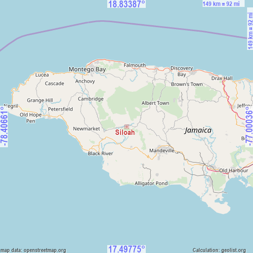
Siloah GPS coordinates[2]
18° 10' 1.524" North, 77° 42' 12.528" West
| Map corner | latitude | longitude |
|---|---|---|
| Upper-left | 18.83387°, | -78.40661° |
| Center: | 18.16709°, | -77.70348° |
| Lower-right: | 17.49775°, | -77.00036° |
| Map W x H: | 148.6×148.6 km | = 92.3×92.3mi |
| max Lat: | 18.49358° ⇑45.1% North |
| Siloah: | 18.16709° |
| min Lat: | ⇓54.9% South 17.774° |
| min Long | Siloah | max Long |
| -78.3481° | -77.70348° | -76.24864° |
| W 20.9%⇐ | ⇒79.1% E |
Elevation
Elevation of Siloah is 141 m = 463 ft, and this is 73.4 m = 241 ft below average elevation for this country.
| Max E: |
944 m = 3097 ft | 44% |
| Avg. | 214.4 m = 703 ft | |
| Siloah | 141 m = 463 ft | |
Min E: |
1 m = 3 ft | 56% |
See also: Jamaica elevation on elevation.city.
Geographical zone
Siloah is located in North Torrid zone (between Equator and Tropic of Cancer). Distance of this Northern Tropic circle is 585.9 km =364.1 mi to North.| Distance of | km | miles | from Siloah |
|---|---|---|---|
| North Pole | 7987.1 | 4963 | to North |
| Arctic Circle | 5381.2 | 3343.7 | to North |
| Tropic Cancer | 585.9 | 364.1 | to North |
| Equator | 2020 | 1255.2 | to South |


Nearby cities:
15 places around Siloah: (largest is in red/bold)
• Albert Town
22.1 km =13.7 mi,  50°
50°
• Balaclava
6.3 km =3.9 mi,  84°
84°
• Black River
21.9 km =13.6 mi,  224°
224°
• Coleyville
21.2 km =13.2 mi, 77°
• Lacovia
11.7 km =7.3 mi,  205°
205°
• Limit
24.6 km =15.3 mi,  93°
93°
• Maggotty
6.4 km =4 mi,  263°
263°
• Malvern
22.3 km =13.9 mi,  179°
179°
• Mandeville
25 km =15.5 mi,  123°
123°
• Maroon Town
22 km =13.7 mi,  333°
333°
• Nain
24.7 km =15.3 mi,  155°
155°
• Quickstep
12.2 km =7.6 mi,  29°
29°
• Rock Spring
21.8 km =13.5 mi, 46°
• Santa Cruz
12.7 km =7.9 mi, 177°
• Ulster Spring
25.3 km =15.7 mi, 49°
Sources, notices
• [Note1] Compared only with cities in Jamaica existing in our database
• [Src1] Map data: © OpenStreetMap contributors (CC-BY-SA)
• [Src2] Other city data from geonames.org with taken over terms of usage.
• [Src3] Geographical zone / Annual Mean Temperature by Robert A. Rohde @ Wikipedia
