Al Fayşalīyah geodata
Al Fayşalīyah (Madaba) is a seat of a third-order administrative division; located in Jordan in Asia/Amman (GMT+3) time zone. In our database, there are 84 cities with bigger population. Compared to other cities in Jordan, 71.7% of cities are located further ↑North; 58.7% of cities are located further →East and 63% of cities have lower elevation than Al Fayşalīyah. Note1


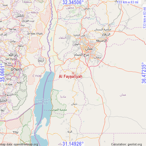
Al Fayşalīyah GPS coordinates[2]
31° 44' 56.724" North, 35° 46' 9.192" East
| Map corner | latitude | longitude |
|---|---|---|
| Upper-left | 32.34506°, | 35.0661° |
| Center: | 31.74909°, | 35.76922° |
| Lower-right: | 31.14926°, | 36.47235° |
| Map W x H: | 133×133 km | = 82.6×82.6mi |
| max Lat: | 33.31405° ⇑71.7% North |
| Al Fayşalīyah: | 31.74909° |
| min Lat: | ⇓28.3% South 29.40842° |
| min Long | Al Fayşalīyah | max Long |
| 34.97918° | 35.76922° | 38.70342° |
| W 41.3%⇐ | ⇒58.7% E |
Elevation
Elevation of Al Fayşalīyah is 811 m = 2661 ft, and this is 125.3 m = 411 ft above average elevation for this country.
| Max E: |
1440 m = 4724 ft | 37% |
| Al Fayşalīyah | 811 m 2661 ft | |
| Avg. | 685.7 m = 2250 ft | |
Min E: |
-366 m = -1201 ft | 63% |
See also: Jordan elevation on elevation.city.
Geographical zone
Al Fayşalīyah is located in North temperate zone (between Tropic of Cancer and the Arctic Circle). Distance of this Northern Tropic circle is 924.2 km =574.3 mi to South.| Distance of | km | miles | from Al Fayşalīyah |
|---|---|---|---|
| North Pole | 6476.9 | 4024.6 | to North |
| Arctic Circle | 3871 | 2405.3 | to North |
| Tropic Cancer | 924.2 | 574.3 | to South |
| Equator | 3530.2 | 2193.6 | to South |


Nearby cities:
15 places around Al Fayşalīyah: (largest is in red/bold)
• Al Juwayyidah
21.7 km =13.5 mi,  44°
44°
• Al Jīzah
18.5 km =11.5 mi,  107°
107°
• Al ‘Arīḑ
23.7 km =14.7 mi,  206°
206°
• Ash Shūnah al Janūbīyah
21.3 km =13.2 mi,  317°
317°
• Juraynah
2.7 km =1.7 mi,  63°
63°
• Jāwā
19.8 km =12.3 mi,  54°
54°
• Mulayḩ
18.6 km =11.6 mi,  168°
168°
• Mādabā
4.4 km =2.7 mi,  147°
147°
• Mā‘īn
8.4 km =5.2 mi,  204°
204°
• Nā‘ūr
14.9 km =9.3 mi,  20°
20°
• Umm al Basātīn
13.3 km =8.3 mi, 50°
• Umm as Summāq
17.2 km =10.7 mi,  27°
27°
• Wādī as Sīr
23.3 km =14.5 mi,  11°
11°
• Ḩayy al Bunayyāt
19.6 km =12.2 mi, 33°
• Ḩisbān
6.7 km =4.2 mi, 35°
Sources, notices
• [Note1] Compared only with cities in Jordan existing in our database
• [Src1] Map data: © OpenStreetMap contributors (CC-BY-SA)
• [Src2] Other city data from geonames.org with taken over terms of usage.
• [Src3] Geographical zone / Annual Mean Temperature by Robert A. Rohde @ Wikipedia
