Ash Shūnah al Janūbīyah geodata
Ash Shūnah al Janūbīyah (Balqa) is a seat of a second-order administrative division; located in Jordan in Asia/Amman (GMT+3) time zone. In our database, there are 84 cities with bigger population. Compared to other cities in Jordan, 62.3% of cities are located further ↑North; 84.8% of cities are located further →East and 97.8% of cities have higher elevation than Ash Shūnah al Janūbīyah. Note1
Current local time in Ash Shūnah al Janūbīyah:
12:05 AM, FridayDifference from your time zone: hours


Ash Shūnah al Janūbīyah GPS coordinates[2]
31° 53' 29.4" North, 35° 37' 4.08" East
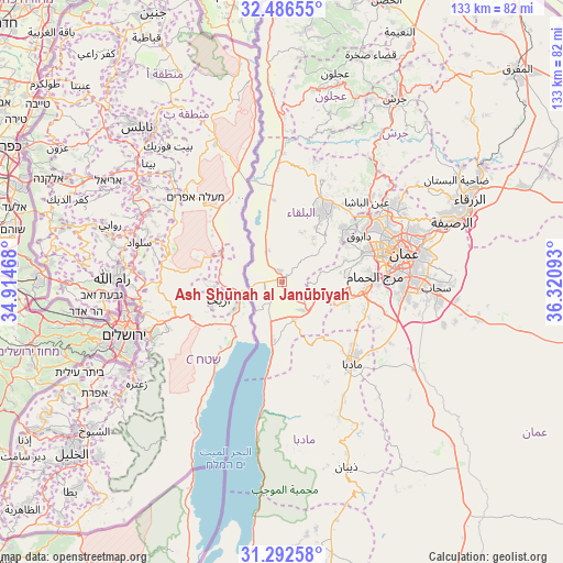
| Map corner | latitude | longitude |
|---|---|---|
| Upper-left | 32.48655°, | 34.91468° |
| Center: | 31.8915°, | 35.6178° |
| Lower-right: | 31.29258°, | 36.32093° |
| Map W x H: | 132.8×132.8 km | = 82.5×82.5mi |
| max Lat: | 33.31405° ⇑62.3% North |
| Ash Shūnah al Janūbīyah: | 31.8915° |
| min Lat: | ⇓37.7% South 29.40842° |
| min Long | Ash Shūnah al | max Long |
| 34.97918° | 35.6178° | 38.70342° |
| W 15.2%⇐ | ⇒84.8% E |
Elevation
Elevation of Ash Shūnah al Janūbīyah is -233 m = -764 ft, and this is 918.7 m = 3014 ft below average elevation for this country.
| Max E: |
1440 m = 4724 ft | 97.8% |
| Avg. | 685.7 m = 2250 ft | |
| Ash Shūnah al Janūbīyah | -233 m = -764 ft | |
Min E: |
-366 m = -1201 ft | 2.2% |
See also: Jordan elevation on elevation.city.
Geographical zone
Ash Shūnah al Janūbīyah is located in North temperate zone (between Tropic of Cancer and the Arctic Circle). Distance of this Northern Tropic circle is 940.1 km =584.2 mi to South.| Distance of | km | miles | from Ash Shūnah al Janūbīyah |
|---|---|---|---|
| North Pole | 6461.1 | 4014.7 | to North |
| Arctic Circle | 3855.2 | 2395.5 | to North |
| Tropic Cancer | 940.1 | 584.2 | to South |
| Equator | 3546 | 2203.4 | to South |


Nearby cities:
15 places around Ash Shūnah al Janūbīyah: (largest is in red/bold)
• Al Fayşalīyah
21.3 km =13.2 mi,  137°
137°
• Al Fuḩayş
19.9 km =12.4 mi,  50°
50°
• Al Karāmah
7.8 km =4.8 mi,  333°
333°
• As Salţ
19.4 km =12.1 mi,  32°
32°
• Juraynah
22.2 km =13.8 mi,  131°
131°
• Mādabā
25.6 km =15.9 mi, 139°
• Mā‘īn
25.9 km =16.1 mi,  155°
155°
• Nā‘ūr
19.6 km =12.2 mi,  95°
95°
• Umm al Basātīn
25.7 km =16 mi,  106°
106°
• Umm as Summāq
22.3 km =13.9 mi,  91°
91°
• Wādī as Sīr
20.2 km =12.6 mi,  69°
69°
• Yarqā
12 km =7.5 mi,  38°
38°
• Ḩayy al Bunayyāt
25.2 km =15.7 mi, 88°
• Ḩisbān
20.9 km =13 mi,  119°
119°
• ‘Ayn al Bāshā
27.3 km =17 mi, 47°
Sources, notices
• [Note1] Compared only with cities in Jordan existing in our database
• [Src1] Map data: © OpenStreetMap contributors (CC-BY-SA)
• [Src2] Other city data from geonames.org with taken over terms of usage.
• [Src3] Geographical zone / Annual Mean Temperature by Robert A. Rohde @ Wikipedia
