Nā‘ūr geodata
Nā‘ūr (Amman) is a seat of a second-order administrative division; located in Jordan in Asia/Amman (GMT+3) time zone. In our database, there are 84 cities with bigger population. Compared to other cities in Jordan, 65.2% of cities are located further ↑North; 55.1% of cities are located further ←West and 60.9% of cities have lower elevation than Nā‘ūr. Note1


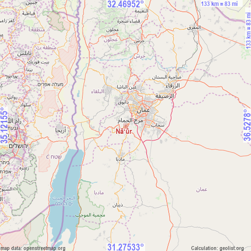
Nā‘ūr GPS coordinates[2]
31° 52' 27.696" North, 35° 49' 28.812" East
| Map corner | latitude | longitude |
|---|---|---|
| Upper-left | 32.46952°, | 35.12155° |
| Center: | 31.87436°, | 35.82467° |
| Lower-right: | 31.27533°, | 36.5278° |
| Map W x H: | 132.8×132.8 km | = 82.5×82.5mi |
| max Lat: | 33.31405° ⇑65.2% North |
| Nā‘ūr: | 31.87436° |
| min Lat: | ⇓34.8% South 29.40842° |
| min Long | Nā‘ūr | max Long |
| 34.97918° | 35.82467° | 38.70342° |
| W 55.1%⇐ | ⇒44.9% E |
Elevation
Elevation of Nā‘ūr is 797 m = 2615 ft, and this is 111.3 m = 365 ft above average elevation for this country.
| Max E: |
1440 m = 4724 ft | 39.1% |
| Nā‘ūr | 797 m 2615 ft | |
| Avg. | 685.7 m = 2250 ft | |
Min E: |
-366 m = -1201 ft | 60.9% |
See also: Jordan elevation on elevation.city.
Geographical zone
Nā‘ūr is located in North temperate zone (between Tropic of Cancer and the Arctic Circle). Distance of this Northern Tropic circle is 938.2 km =583 mi to South.| Distance of | km | miles | from Nā‘ūr |
|---|---|---|---|
| North Pole | 6463 | 4015.9 | to North |
| Arctic Circle | 3857.1 | 2396.7 | to North |
| Tropic Cancer | 938.2 | 583 | to South |
| Equator | 3544.1 | 2202.2 | to South |


Nearby cities:
15 places around Nā‘ūr: (largest is in red/bold)
• Al Fayşalīyah
14.9 km =9.3 mi,  200°
200°
• Al Fuḩayş
15.1 km =9.4 mi,  344°
344°
• Al Jubayhah
16.7 km =10.4 mi,  24°
24°
• Al Juwayyidah
10.2 km =6.3 mi,  81°
81°
• Al ‘Abdallī
12.8 km =8 mi,  38°
38°
• Amman
14.5 km =9 mi,  51°
51°
• Juraynah
13 km =8.1 mi,  192°
192°
• Jāwā
11.1 km =6.9 mi,  102°
102°
• Umm al Basātīn
7.5 km =4.7 mi,  137°
137°
• Umm as Summāq
3.1 km =1.9 mi,  66°
66°
• Wādī as Sīr
8.9 km =5.5 mi,  356°
356°
• Yarqā
16.5 km =10.3 mi,  312°
312°
• Ḩayy al Bunayyāt
6.2 km =3.9 mi, 66°
• Ḩayy al Quwaysimah
12.5 km =7.8 mi, 71°
• Ḩisbān
8.6 km =5.3 mi, 189°
Sources, notices
• [Note1] Compared only with cities in Jordan existing in our database
• [Src1] Map data: © OpenStreetMap contributors (CC-BY-SA)
• [Src2] Other city data from geonames.org with taken over terms of usage.
• [Src3] Geographical zone / Annual Mean Temperature by Robert A. Rohde @ Wikipedia
