Yonago geodata
Yonago (Tottori) is a seat of a second-order administrative division; located in Japan in Asia/Tokyo (GMT+9) time zone. With population of 141,368 people, there are 146 cities with bigger population in this country. Compared to other cities in Japan, 51.7% of cities are located further ↓South; 78.1% of cities are located further →East and 76.3% of cities have higher elevation than Yonago. Note1


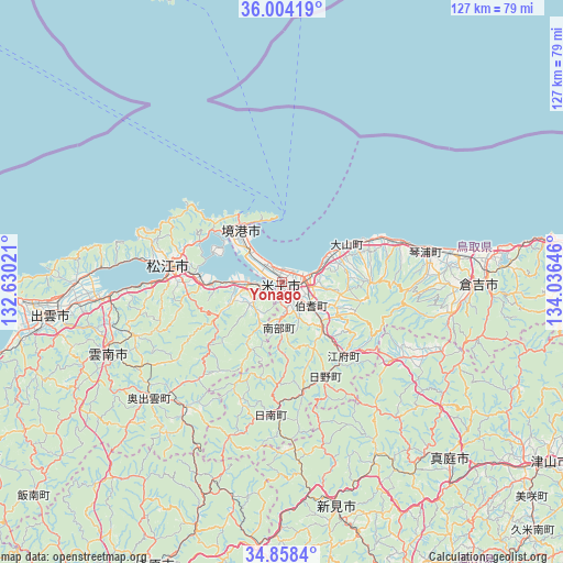
Yonago GPS coordinates[2]
35° 25' 59.988" North, 133° 19' 59.988" East
| Map corner | latitude | longitude |
|---|---|---|
| Upper-left | 36.00419°, | 132.63021° |
| Center: | 35.43333°, | 133.33333° |
| Lower-right: | 34.8584°, | 134.03646° |
| Map W x H: | 127.4×127.4 km | = 79.2×79.2mi |
| max Lat: | 45.40944° ⇑48.3% North |
| Yonago: | 35.43333° |
| min Lat: | ⇓51.7% South 24.34478° |
| min Long | Yonago | max Long |
| 123° | 133.33333° | 145.575° |
| W 21.9%⇐ | ⇒78.1% E |
Elevation
Elevation of Yonago is 9 m = 30 ft, and this is 75.6 m = 248 ft below average elevation for this country.
| Max E: |
1086 m = 3563 ft | 76.3% |
| Avg. | 84.6 m = 278 ft | |
| Yonago | 9 m = 30 ft | |
Min E: |
-2 m = -7 ft | 23.7% |
See also: Yonago elevation on elevation.city.
Geographical zone
Yonago is located in North temperate zone (between Tropic of Cancer and the Arctic Circle). Distance of this Northern Tropic circle is 1333.9 km =828.8 mi to South.| Distance of | km | miles | from Yonago |
|---|---|---|---|
| North Pole | 6067.2 | 3770 | to North |
| Arctic Circle | 3461.4 | 2150.8 | to North |
| Tropic Cancer | 1333.9 | 828.8 | to South |
| Equator | 3939.8 | 2448.1 | to South |


Nearby cities:
15 places around Yonago: (largest is in red/bold)
• Hiratachō
46.8 km =29.1 mi,  270°
270°
• Izumo
51.9 km =32.2 mi,  261°
261°
• Kurayoshi
43.8 km =27.2 mi,  90°
90°
• Maniwa
50.5 km =31.4 mi,  135°
135°
• Matsue
26.3 km =16.3 mi,  282°
282°
• Niimi
51.5 km =32 mi,  166°
166°
• Oda
79.9 km =49.6 mi,  251°
251°
• Sakaiminato
14.9 km =9.3 mi,  321°
321°
• Shōbara
71 km =44.1 mi,  203°
203°
• Takahashi
76.7 km =47.7 mi,  160°
160°
• Tsuyama
73.8 km =45.9 mi,  125°
125°
• Unnan
44.6 km =27.7 mi,  241°
241°
• Yasugi
17.3 km =10.7 mi,  231°
231°
• Yasugichō
8.4 km =5.2 mi, 260°
• Ōdachō-ōda
79.6 km =49.5 mi, 250°
Sources, notices
• [Note1] Compared only with cities in Japan existing in our database
• [Src1] Map data: © OpenStreetMap contributors (CC-BY-SA)
• [Src2] Other city data from geonames.org with taken over terms of usage.
• [Src3] Geographical zone / Annual Mean Temperature by Robert A. Rohde @ Wikipedia
