Maniwa geodata
Maniwa (Okayama) is a seat of a second-order administrative division; located in Japan in Asia/Tokyo (GMT+9) time zone. In our database, there are 767 cities with bigger population. Compared to other cities in Japan, 56.1% of cities are located further ↑North; 76.4% of cities are located further →East and 89.9% of cities have lower elevation than Maniwa. Note1


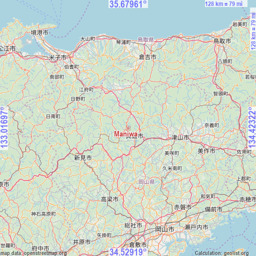
Maniwa GPS coordinates[2]
35° 6' 23.148" North, 133° 43' 12.324" East
| Map corner | latitude | longitude |
|---|---|---|
| Upper-left | 35.67961°, | 133.01697° |
| Center: | 35.10643°, | 133.72009° |
| Lower-right: | 34.52919°, | 134.42322° |
| Map W x H: | 127.9×127.9 km | = 79.5×79.5mi |
| max Lat: | 45.40944° ⇑56.1% North |
| Maniwa: | 35.10643° |
| min Lat: | ⇓43.9% South 24.34478° |
| min Long | Maniwa | max Long |
| 123° | 133.72009° | 145.575° |
| W 23.6%⇐ | ⇒76.4% E |
Elevation
Elevation of Maniwa is 222 m = 728 ft, and this is 137.4 m = 451 ft above average elevation for this country.
| Max E: |
1086 m = 3563 ft | 10.1% |
| Maniwa | 222 m 728 ft | |
| Avg. | 84.6 m = 278 ft | |
Min E: |
-2 m = -7 ft | 89.9% |
See also: Japan elevation on elevation.city.
Geographical zone
Maniwa is located in North temperate zone (between Tropic of Cancer and the Arctic Circle). Distance of this Northern Tropic circle is 1297.6 km =806.3 mi to South.| Distance of | km | miles | from Maniwa |
|---|---|---|---|
| North Pole | 6103.6 | 3792.6 | to North |
| Arctic Circle | 3497.7 | 2173.4 | to North |
| Tropic Cancer | 1297.6 | 806.3 | to South |
| Equator | 3903.5 | 2425.5 | to South |


Nearby cities:
15 places around Maniwa: (largest is in red/bold)
• Akaiwa
42.9 km =26.7 mi,  140°
140°
• Bizen
58.9 km =36.6 mi,  127°
127°
• Ibara
60.9 km =37.8 mi,  202°
202°
• Kurashiki
58.3 km =36.2 mi,  175°
175°
• Kurayoshi
37.4 km =23.2 mi,  13°
13°
• Mimasaka
46.5 km =28.9 mi,  98°
98°
• Niimi
26.8 km =16.7 mi,  239°
239°
• Okayama
54.4 km =33.8 mi,  159°
159°
• Setouchi
62.9 km =39.1 mi, 142°
• Sōja
48 km =29.8 mi, 176°
• Takahashi
37.1 km =23.1 mi,  194°
194°
• Tsuyama
26.1 km =16.2 mi, 103°
• Yasugi
55 km =34.2 mi,  297°
297°
• Yasugichō
55.8 km =34.7 mi,  308°
308°
• Yonago
50.5 km =31.4 mi,  315°
315°
Sources, notices
• [Note1] Compared only with cities in Japan existing in our database
• [Src1] Map data: © OpenStreetMap contributors (CC-BY-SA)
• [Src2] Other city data from geonames.org with taken over terms of usage.
• [Src3] Geographical zone / Annual Mean Temperature by Robert A. Rohde @ Wikipedia
