Tsuyama geodata
Tsuyama (Okayama) is a seat of a second-order administrative division; located in Japan in Asia/Tokyo (GMT+9) time zone. With population of 89,717 people, there are 223 cities with bigger population in this country. Compared to other cities in Japan, 57.1% of cities are located further ↑North; 75% of cities are located further →East and 75.3% of cities have lower elevation than Tsuyama. Note1


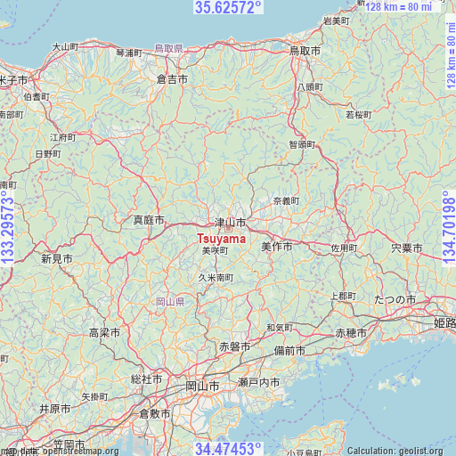
Tsuyama GPS coordinates[2]
35° 3' 7.74" North, 133° 59' 55.86" East
| Map corner | latitude | longitude |
|---|---|---|
| Upper-left | 35.62572°, | 133.29573° |
| Center: | 35.05215°, | 133.99885° |
| Lower-right: | 34.47453°, | 134.70198° |
| Map W x H: | 128×128 km | = 79.5×79.5mi |
| max Lat: | 45.40944° ⇑57.1% North |
| Tsuyama: | 35.05215° |
| min Lat: | ⇓42.9% South 24.34478° |
| min Long | Tsuyama | max Long |
| 123° | 133.99885° | 145.575° |
| W 25%⇐ | ⇒75% E |
Elevation
Elevation of Tsuyama is 97 m = 318 ft, and this is 12.4 m = 41 ft above average elevation for this country.
| Max E: |
1086 m = 3563 ft | 24.7% |
| Tsuyama | 97 m 318 ft | |
| Avg. | 84.6 m = 278 ft | |
Min E: |
-2 m = -7 ft | 75.3% |
See also: Tsuyama elevation on elevation.city.
Geographical zone
Tsuyama is located in North temperate zone (between Tropic of Cancer and the Arctic Circle). Distance of this Northern Tropic circle is 1291.5 km =802.5 mi to South.| Distance of | km | miles | from Tsuyama |
|---|---|---|---|
| North Pole | 6109.6 | 3796.3 | to North |
| Arctic Circle | 3503.7 | 2177.1 | to North |
| Tropic Cancer | 1291.5 | 802.5 | to South |
| Equator | 3897.4 | 2421.7 | to South |


Nearby cities:
15 places around Tsuyama: (largest is in red/bold)
• Aioi
50.9 km =31.6 mi,  122°
122°
• Akaiwa
27 km =16.8 mi,  175°
175°
• Ako
47 km =29.2 mi,  133°
133°
• Bizen
36.6 km =22.7 mi,  143°
143°
• Kariya
48.7 km =30.3 mi, 133°
• Kurayoshi
45.5 km =28.3 mi,  338°
338°
• Maniwa
26.1 km =16.2 mi,  283°
283°
• Mimasaka
20.6 km =12.8 mi,  93°
93°
• Niimi
49.1 km =30.5 mi,  261°
261°
• Okayama
45.1 km =28 mi,  187°
187°
• Setouchi
45.6 km =28.3 mi,  163°
163°
• Shisō
52.1 km =32.4 mi,  98°
98°
• Sōja
47.6 km =29.6 mi,  208°
208°
• Takahashi
45.9 km =28.5 mi,  229°
229°
• Yamazakichō-nakabirose
50.5 km =31.4 mi, 96°
Sources, notices
• [Note1] Compared only with cities in Japan existing in our database
• [Src1] Map data: © OpenStreetMap contributors (CC-BY-SA)
• [Src2] Other city data from geonames.org with taken over terms of usage.
• [Src3] Geographical zone / Annual Mean Temperature by Robert A. Rohde @ Wikipedia
