Ueda geodata
Ueda (Nagano) is a seat of a second-order administrative division; located in Japan in Asia/Tokyo (GMT+9) time zone. With population of 126,606 people, there are 167 cities with bigger population in this country. Compared to other cities in Japan, 76% of cities are located further ↓South; 55.3% of cities are located further ←West and 97.2% of cities have lower elevation than Ueda. Note1


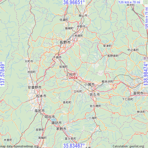
Ueda GPS coordinates[2]
36° 24' 9.54" North, 138° 16' 53.796" East
| Map corner | latitude | longitude |
|---|---|---|
| Upper-left | 36.96651°, | 137.57849° |
| Center: | 36.40265°, | 138.28161° |
| Lower-right: | 35.83467°, | 138.98474° |
| Map W x H: | 125.8×125.8 km | = 78.2×78.2mi |
| max Lat: | 45.40944° ⇑24% North |
| Ueda: | 36.40265° |
| min Lat: | ⇓76% South 24.34478° |
| min Long | Ueda | max Long |
| 123° | 138.28161° | 145.575° |
| W 55.3%⇐ | ⇒44.7% E |
Elevation
Elevation of Ueda is 536 m = 1759 ft, and this is 451.4 m = 1481 ft above average elevation for this country.
| Max E: |
1086 m = 3563 ft | 2.8% |
| Ueda | 536 m 1759 ft | |
| Avg. | 84.6 m = 278 ft | |
Min E: |
-2 m = -7 ft | 97.2% |
See also: Ueda elevation on elevation.city.
Geographical zone
Ueda is located in North temperate zone (between Tropic of Cancer and the Arctic Circle). Distance of this Northern Tropic circle is 1441.7 km =895.8 mi to South.| Distance of | km | miles | from Ueda |
|---|---|---|---|
| North Pole | 5959.5 | 3703.1 | to North |
| Arctic Circle | 3353.6 | 2083.8 | to North |
| Tropic Cancer | 1441.7 | 895.8 | to South |
| Equator | 4047.6 | 2515.1 | to South |


Nearby cities:
15 places around Ueda: (largest is in red/bold)
• Azumino
37.6 km =23.4 mi,  250°
250°
• Chikuma
22.1 km =13.7 mi,  308°
308°
• Hotaka
36.4 km =22.6 mi,  258°
258°
• Kamimaruko
9.4 km =5.8 mi,  184°
184°
• Komoro
16.6 km =10.3 mi,  125°
125°
• Matsumoto
33.9 km =21.1 mi,  236°
236°
• Nagano
28.9 km =18 mi,  342°
342°
• Nakano
39.4 km =24.5 mi,  11°
11°
• Okaya
43.9 km =27.3 mi,  208°
208°
• Saku
27.5 km =17.1 mi,  138°
138°
• Suwa
43.3 km =26.9 mi,  200°
200°
• Suzaka
27.7 km =17.2 mi, 6°
• Toyoshina
35.9 km =22.3 mi, 251°
• Tōmi
8.8 km =5.5 mi, 126°
• Ōmachi
38.7 km =24 mi,  286°
286°
Sources, notices
• [Note1] Compared only with cities in Japan existing in our database
• [Src1] Map data: © OpenStreetMap contributors (CC-BY-SA)
• [Src2] Other city data from geonames.org with taken over terms of usage.
• [Src3] Geographical zone / Annual Mean Temperature by Robert A. Rohde @ Wikipedia
