Hotaka geodata
Hotaka (Nagano) is a populated place; located in Japan in Asia/Tokyo (GMT+9) time zone. With population of 33,195 people, there are 514 cities with bigger population in this country. Compared to other cities in Japan, 74.8% of cities are located further ↓South; 52.8% of cities are located further ←West and 97.3% of cities have lower elevation than Hotaka. Note1


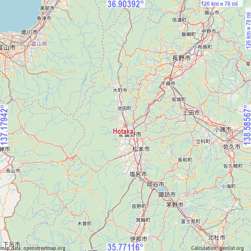
Hotaka GPS coordinates[2]
36° 20' 22.56" North, 137° 52' 57.144" East
| Map corner | latitude | longitude |
|---|---|---|
| Upper-left | 36.90392°, | 137.17942° |
| Center: | 36.3396°, | 137.88254° |
| Lower-right: | 35.77116°, | 138.58567° |
| Map W x H: | 126×126 km | = 78.3×78.3mi |
| max Lat: | 45.40944° ⇑25.2% North |
| Hotaka: | 36.3396° |
| min Lat: | ⇓74.8% South 24.34478° |
| min Long | Hotaka | max Long |
| 123° | 137.88254° | 145.575° |
| W 52.8%⇐ | ⇒47.2% E |
Elevation
Elevation of Hotaka is 547 m = 1795 ft, and this is 462.4 m = 1517 ft above average elevation for this country.
| Max E: |
1086 m = 3563 ft | 2.7% |
| Hotaka | 547 m 1795 ft | |
| Avg. | 84.6 m = 278 ft | |
Min E: |
-2 m = -7 ft | 97.3% |
See also: Japan elevation on elevation.city.
Geographical zone
Hotaka is located in North temperate zone (between Tropic of Cancer and the Arctic Circle). Distance of this Northern Tropic circle is 1434.7 km =891.5 mi to South.| Distance of | km | miles | from Hotaka |
|---|---|---|---|
| North Pole | 5966.5 | 3707.4 | to North |
| Arctic Circle | 3360.6 | 2088.2 | to North |
| Tropic Cancer | 1434.7 | 891.5 | to South |
| Equator | 4040.6 | 2510.7 | to South |


Nearby cities:
15 places around Hotaka: (largest is in red/bold)
• Azumino
5.7 km =3.5 mi,  175°
175°
• Chikuma
27.9 km =17.3 mi,  41°
41°
• Chino
45.5 km =28.3 mi,  147°
147°
• Hakuba
39.9 km =24.8 mi,  357°
357°
• Kamimaruko
35.1 km =21.8 mi,  93°
93°
• Matsumoto
14 km =8.7 mi, 147°
• Nagano
43.7 km =27.2 mi, 37°
• Okaya
34.7 km =21.6 mi,  155°
155°
• Shiojiri
27.7 km =17.2 mi, 164°
• Suwa
39.4 km =24.5 mi, 148°
• Tatsuno
40.8 km =25.4 mi,  165°
165°
• Toyoshina
4.7 km =2.9 mi, 159°
• Tōmi
42.9 km =26.7 mi, 87°
• Ueda
36.4 km =22.6 mi,  78°
78°
• Ōmachi
17.9 km =11.1 mi, 355°
Sources, notices
• [Note1] Compared only with cities in Japan existing in our database
• [Src1] Map data: © OpenStreetMap contributors (CC-BY-SA)
• [Src2] Other city data from geonames.org with taken over terms of usage.
• [Src3] Geographical zone / Annual Mean Temperature by Robert A. Rohde @ Wikipedia
