Kamimaruko geodata
Kamimaruko (Nagano) is a populated place; located in Japan in Asia/Tokyo (GMT+9) time zone. With population of 25,403 people, there are 607 cities with bigger population in this country. Compared to other cities in Japan, 74.4% of cities are located further ↓South; 55.2% of cities are located further ←West and 97.6% of cities have lower elevation than Kamimaruko. Note1


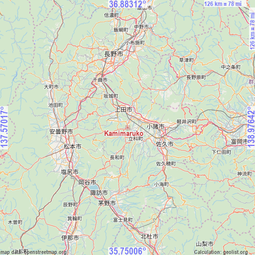
Kamimaruko GPS coordinates[2]
36° 19' 7.14" North, 138° 16' 23.844" East
| Map corner | latitude | longitude |
|---|---|---|
| Upper-left | 36.88312°, | 137.57017° |
| Center: | 36.31865°, | 138.27329° |
| Lower-right: | 35.75006°, | 138.97642° |
| Map W x H: | 126×126 km | = 78.3×78.3mi |
| max Lat: | 45.40944° ⇑25.6% North |
| Kamimaruko: | 36.31865° |
| min Lat: | ⇓74.4% South 24.34478° |
| min Long | Kamimaruko | max Long |
| 123° | 138.27329° | 145.575° |
| W 55.2%⇐ | ⇒44.8% E |
Elevation
Elevation of Kamimaruko is 563 m = 1847 ft, and this is 478.4 m = 1570 ft above average elevation for this country.
| Max E: |
1086 m = 3563 ft | 2.4% |
| Kamimaruko | 563 m 1847 ft | |
| Avg. | 84.6 m = 278 ft | |
Min E: |
-2 m = -7 ft | 97.6% |
See also: Japan elevation on elevation.city.
Geographical zone
Kamimaruko is located in North temperate zone (between Tropic of Cancer and the Arctic Circle). Distance of this Northern Tropic circle is 1432.3 km =890 mi to South.| Distance of | km | miles | from Kamimaruko |
|---|---|---|---|
| North Pole | 5968.8 | 3708.8 | to North |
| Arctic Circle | 3362.9 | 2089.6 | to North |
| Tropic Cancer | 1432.3 | 890 | to South |
| Equator | 4038.3 | 2509.3 | to South |


Nearby cities:
15 places around Kamimaruko: (largest is in red/bold)
• Azumino
34.8 km =21.6 mi,  264°
264°
• Chikuma
28.4 km =17.6 mi,  324°
324°
• Chino
37.6 km =23.4 mi,  196°
196°
• Hotaka
35.1 km =21.8 mi,  273°
273°
• Komoro
14.3 km =8.9 mi,  90°
90°
• Matsumoto
29.1 km =18.1 mi,  250°
250°
• Nagano
37.7 km =23.4 mi,  347°
347°
• Okaya
35.6 km =22.1 mi,  215°
215°
• Saku
22 km =13.7 mi,  121°
121°
• Shiojiri
36.7 km =22.8 mi,  228°
228°
• Suwa
34.4 km =21.4 mi, 204°
• Suzaka
37 km =23 mi,  6°
6°
• Toyoshina
33.4 km =20.8 mi, 266°
• Tōmi
8.9 km =5.5 mi,  62°
62°
• Ueda
9.4 km =5.8 mi,  4°
4°
Sources, notices
• [Note1] Compared only with cities in Japan existing in our database
• [Src1] Map data: © OpenStreetMap contributors (CC-BY-SA)
• [Src2] Other city data from geonames.org with taken over terms of usage.
• [Src3] Geographical zone / Annual Mean Temperature by Robert A. Rohde @ Wikipedia
