Nagano geodata
Nagano is a seat of a first-order administrative division; located in Japan in Asia/Tokyo (GMT+9) time zone. With population of 360,176 people, there are 46 cities with bigger population in this country. Compared to other cities in Japan, 79% of cities are located further ↓South; 54.4% of cities are located further ←West and 95.3% of cities have lower elevation than Nagano. Note1


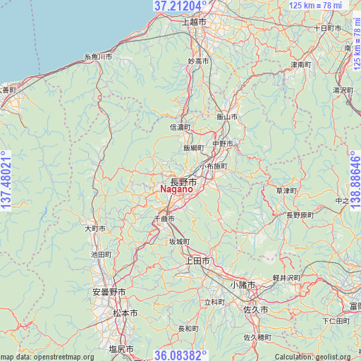
Nagano GPS coordinates[2]
36° 39' 0" North, 138° 10' 59.988" East
| Map corner | latitude | longitude |
|---|---|---|
| Upper-left | 37.21204°, | 137.48021° |
| Center: | 36.65°, | 138.18333° |
| Lower-right: | 36.08382°, | 138.88646° |
| Map W x H: | 125.4×125.4 km | = 77.9×77.9mi |
| max Lat: | 45.40944° ⇑21% North |
| Nagano: | 36.65° |
| min Lat: | ⇓79% South 24.34478° |
| min Long | Nagano | max Long |
| 123° | 138.18333° | 145.575° |
| W 54.4%⇐ | ⇒45.6% E |
Elevation
Elevation of Nagano is 372 m = 1220 ft, and this is 287.4 m = 943 ft above average elevation for this country.
| Max E: |
1086 m = 3563 ft | 4.7% |
| Nagano | 372 m 1220 ft | |
| Avg. | 84.6 m = 278 ft | |
Min E: |
-2 m = -7 ft | 95.3% |
See also: Nagano elevation on elevation.city.
Geographical zone
Nagano is located in North temperate zone (between Tropic of Cancer and the Arctic Circle). Distance of this Northern Tropic circle is 1469.2 km =912.9 mi to South.| Distance of | km | miles | from Nagano |
|---|---|---|---|
| North Pole | 5932 | 3686 | to North |
| Arctic Circle | 3326.1 | 2066.7 | to North |
| Tropic Cancer | 1469.2 | 912.9 | to South |
| Equator | 4075.1 | 2532.1 | to South |


Nearby cities:
15 places around Nagano: (largest is in red/bold)
• Arai
39.2 km =24.4 mi,  5°
5°
• Azumino
48.2 km =30 mi,  213°
213°
• Chikuma
16 km =9.9 mi, 211°
• Hakuba
29.2 km =18.1 mi,  280°
280°
• Hotaka
43.7 km =27.2 mi,  217°
217°
• Iiyama
27.6 km =17.1 mi,  36°
36°
• Kamimaruko
37.7 km =23.4 mi,  167°
167°
• Komoro
43.3 km =26.9 mi,  148°
148°
• Myoko
41.4 km =25.7 mi, 11°
• Nakano
19.8 km =12.3 mi,  55°
55°
• Suzaka
11.9 km =7.4 mi,  90°
90°
• Toyoshina
46.4 km =28.8 mi, 212°
• Tōmi
36.4 km =22.6 mi, 154°
• Ueda
28.9 km =18 mi,  162°
162°
• Ōmachi
32.8 km =20.4 mi,  239°
239°
Sources, notices
• [Note1] Compared only with cities in Japan existing in our database
• [Src1] Map data: © OpenStreetMap contributors (CC-BY-SA)
• [Src2] Other city data from geonames.org with taken over terms of usage.
• [Src3] Geographical zone / Annual Mean Temperature by Robert A. Rohde @ Wikipedia
