Saku geodata
Saku (Nagano) is a seat of a second-order administrative division; located in Japan in Asia/Tokyo (GMT+9) time zone. With population of 68,885 people, there are 280 cities with bigger population in this country. Compared to other cities in Japan, 71.7% of cities are located further ↓South; 56.5% of cities are located further ←West and 98.4% of cities have lower elevation than Saku. Note1


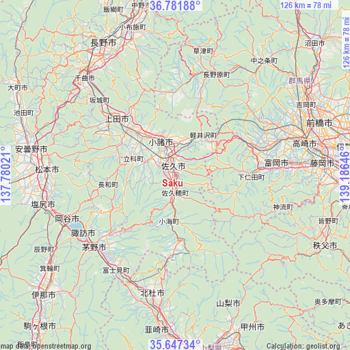
Saku GPS coordinates[2]
36° 13' 0.012" North, 138° 28' 59.988" East
| Map corner | latitude | longitude |
|---|---|---|
| Upper-left | 36.78188°, | 137.78021° |
| Center: | 36.21667°, | 138.48333° |
| Lower-right: | 35.64734°, | 139.18646° |
| Map W x H: | 126.1×126.1 km | = 78.4×78.4mi |
| max Lat: | 45.40944° ⇑28.3% North |
| Saku: | 36.21667° |
| min Lat: | ⇓71.7% South 24.34478° |
| min Long | Saku | max Long |
| 123° | 138.48333° | 145.575° |
| W 56.5%⇐ | ⇒43.5% E |
Elevation
Elevation of Saku is 684 m = 2244 ft, and this is 599.4 m = 1967 ft above average elevation for this country.
| Max E: |
1086 m = 3563 ft | 1.6% |
| Saku | 684 m 2244 ft | |
| Avg. | 84.6 m = 278 ft | |
Min E: |
-2 m = -7 ft | 98.4% |
See also: Saku elevation on elevation.city.
Geographical zone
Saku is located in North temperate zone (between Tropic of Cancer and the Arctic Circle). Distance of this Northern Tropic circle is 1421 km =883 mi to South.| Distance of | km | miles | from Saku |
|---|---|---|---|
| North Pole | 5980.1 | 3715.9 | to North |
| Arctic Circle | 3374.3 | 2096.7 | to North |
| Tropic Cancer | 1421 | 883 | to South |
| Equator | 4026.9 | 2502.2 | to South |


Nearby cities:
15 places around Saku: (largest is in red/bold)
• Annaka
39.1 km =24.3 mi,  71°
71°
• Chikuma
49.3 km =30.6 mi,  314°
314°
• Chino
38.5 km =23.9 mi,  230°
230°
• Hokuto
43.2 km =26.8 mi,  190°
190°
• Kamimaruko
22 km =13.7 mi,  301°
301°
• Komoro
12 km =7.5 mi,  338°
338°
• Matsumoto
46.4 km =28.8 mi,  272°
272°
• Okaya
43.2 km =26.8 mi,  245°
245°
• Shiojiri
48.2 km =30 mi, 254°
• Suwa
38.7 km =24 mi,  239°
239°
• Takasaki
49.5 km =30.8 mi, 74°
• Tomioka
37.4 km =23.2 mi,  83°
83°
• Tōmi
19 km =11.8 mi,  324°
324°
• Ueda
27.5 km =17.1 mi, 318°
• Yoshii
45 km =28 mi,  85°
85°
Sources, notices
• [Note1] Compared only with cities in Japan existing in our database
• [Src1] Map data: © OpenStreetMap contributors (CC-BY-SA)
• [Src2] Other city data from geonames.org with taken over terms of usage.
• [Src3] Geographical zone / Annual Mean Temperature by Robert A. Rohde @ Wikipedia
