Tsuruga geodata
Tsuruga (Fukui) is a seat of a second-order administrative division; located in Japan in Asia/Tokyo (GMT+9) time zone. With population of 68,482 people, there are 285 cities with bigger population in this country. Compared to other cities in Japan, 56.1% of cities are located further ↓South; 61.3% of cities are located further →East and 86% of cities have higher elevation than Tsuruga. Note1


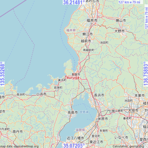
Tsuruga GPS coordinates[2]
35° 38' 43.692" North, 136° 3' 20.88" East
| Map corner | latitude | longitude |
|---|---|---|
| Upper-left | 36.21481°, | 135.35268° |
| Center: | 35.64547°, | 136.0558° |
| Lower-right: | 35.07205°, | 136.75893° |
| Map W x H: | 127.1×127.1 km | = 79×79mi |
| max Lat: | 45.40944° ⇑43.9% North |
| Tsuruga: | 35.64547° |
| min Lat: | ⇓56.1% South 24.34478° |
| min Long | Tsuruga | max Long |
| 123° | 136.0558° | 145.575° |
| W 38.7%⇐ | ⇒61.3% E |
Elevation
Elevation of Tsuruga is 6 m = 20 ft, and this is 78.6 m = 258 ft below average elevation for this country.
| Max E: |
1086 m = 3563 ft | 86% |
| Avg. | 84.6 m = 278 ft | |
| Tsuruga | 6 m = 20 ft | |
Min E: |
-2 m = -7 ft | 14% |
See also: Tsuruga elevation on elevation.city.
Geographical zone
Tsuruga is located in North temperate zone (between Tropic of Cancer and the Arctic Circle). Distance of this Northern Tropic circle is 1357.5 km =843.5 mi to South.| Distance of | km | miles | from Tsuruga |
|---|---|---|---|
| North Pole | 6043.7 | 3755.4 | to North |
| Arctic Circle | 3437.8 | 2136.1 | to North |
| Tropic Cancer | 1357.5 | 843.5 | to South |
| Equator | 3963.4 | 2462.7 | to South |


Nearby cities:
15 places around Tsuruga: (largest is in red/bold)
• Asahi
36.9 km =22.9 mi,  9°
9°
• Echizen
28.7 km =17.8 mi,  21°
21°
• Fukui-shi
48.9 km =30.4 mi, 17°
• Gōdo
55.4 km =34.4 mi,  117°
117°
• Hikone
47.4 km =29.5 mi,  158°
158°
• Kitahama
54.7 km =34 mi,  193°
193°
• Maibara
42 km =26.1 mi,  150°
150°
• Motosu
50.1 km =31.1 mi,  88°
88°
• Nagahama
34.8 km =21.6 mi, 146°
• Obama
32.6 km =20.3 mi,  239°
239°
• Ono
53.9 km =33.5 mi,  46°
46°
• Sabae
35.4 km =22 mi, 19°
• Takashima
26 km =16.2 mi, 187°
• Takefu
30.4 km =18.9 mi, 19°
• Tarui
53.2 km =33.1 mi,  125°
125°
Sources, notices
• [Note1] Compared only with cities in Japan existing in our database
• [Src1] Map data: © OpenStreetMap contributors (CC-BY-SA)
• [Src2] Other city data from geonames.org with taken over terms of usage.
• [Src3] Geographical zone / Annual Mean Temperature by Robert A. Rohde @ Wikipedia
