Asahi geodata
Asahi (Fukui) is a populated locality; located in Japan in Asia/Tokyo (GMT+9) time zone. With population of 9,800 people, there are 744 cities with bigger population in this country. Compared to other cities in Japan, 66.9% of cities are located further ↓South; 60.8% of cities are located further →East and 60.4% of cities have higher elevation than Asahi. Note1


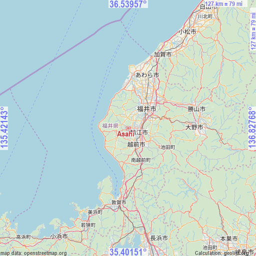
Asahi GPS coordinates[2]
35° 58' 21.324" North, 136° 7' 28.38" East
| Map corner | latitude | longitude |
|---|---|---|
| Upper-left | 36.53957°, | 135.42143° |
| Center: | 35.97259°, | 136.12455° |
| Lower-right: | 35.40151°, | 136.82768° |
| Map W x H: | 126.5×126.5 km | = 78.6×78.6mi |
| max Lat: | 45.40944° ⇑33.1% North |
| Asahi: | 35.97259° |
| min Lat: | ⇓66.9% South 24.34478° |
| min Long | Asahi | max Long |
| 123° | 136.12455° | 145.575° |
| W 39.2%⇐ | ⇒60.8% E |
Elevation
Elevation of Asahi is 19 m = 62 ft, and this is 65.6 m = 215 ft below average elevation for this country.
| Max E: |
1086 m = 3563 ft | 60.4% |
| Avg. | 84.6 m = 278 ft | |
| Asahi | 19 m = 62 ft | |
Min E: |
-2 m = -7 ft | 39.6% |
See also: Japan elevation on elevation.city.
Geographical zone
Asahi is located in North temperate zone (between Tropic of Cancer and the Arctic Circle). Distance of this Northern Tropic circle is 1393.9 km =866.1 mi to South.| Distance of | km | miles | from Asahi |
|---|---|---|---|
| North Pole | 6007.3 | 3732.8 | to North |
| Arctic Circle | 3401.4 | 2113.5 | to North |
| Tropic Cancer | 1393.9 | 866.1 | to South |
| Equator | 3999.8 | 2485.4 | to South |


Nearby cities:
15 places around Asahi: (largest is in red/bold)
• Awara
28.5 km =17.7 mi,  12°
12°
• Echizen
10.5 km =6.5 mi,  156°
156°
• Fukui-shi
13.5 km =8.4 mi,  40°
40°
• Kaga
40.9 km =25.4 mi,  27°
27°
• Katsuyama
35.3 km =21.9 mi,  73°
73°
• Komatsu
56.1 km =34.9 mi, 31°
• Maruoka
24 km =14.9 mi, 33°
• Mikuni
27.3 km =17 mi, 5°
• Motosu
56.2 km =34.9 mi,  128°
128°
• Ono
32.7 km =20.3 mi,  88°
88°
• Sabae
6.2 km =3.9 mi,  118°
118°
• Sakai
20.4 km =12.7 mi,  17°
17°
• Takashima
62.9 km =39.1 mi,  188°
188°
• Takefu
8.5 km =5.3 mi,  153°
153°
• Tsuruga
36.9 km =22.9 mi, 189°
Sources, notices
• [Note1] Compared only with cities in Japan existing in our database
• [Src1] Map data: © OpenStreetMap contributors (CC-BY-SA)
• [Src2] Other city data from geonames.org with taken over terms of usage.
• [Src3] Geographical zone / Annual Mean Temperature by Robert A. Rohde @ Wikipedia
