Ono geodata
Ono (Fukui) is a seat of a second-order administrative division; located in Japan in Asia/Tokyo (GMT+9) time zone. With population of 37,469 people, there are 477 cities with bigger population in this country. Compared to other cities in Japan, 67% of cities are located further ↓South; 58.5% of cities are located further →East and 85.4% of cities have lower elevation than Ono. Note1


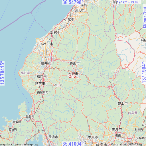
Ono GPS coordinates[2]
35° 58' 51.816" North, 136° 29' 14.172" East
| Map corner | latitude | longitude |
|---|---|---|
| Upper-left | 36.54798°, | 135.78415° |
| Center: | 35.98106°, | 136.48727° |
| Lower-right: | 35.41004°, | 137.1904° |
| Map W x H: | 126.5×126.5 km | = 78.6×78.6mi |
| max Lat: | 45.40944° ⇑33% North |
| Ono: | 35.98106° |
| min Lat: | ⇓67% South 24.34478° |
| min Long | Ono | max Long |
| 123° | 136.48727° | 145.575° |
| W 41.5%⇐ | ⇒58.5% E |
Elevation
Elevation of Ono is 175 m = 574 ft, and this is 90.4 m = 297 ft above average elevation for this country.
| Max E: |
1086 m = 3563 ft | 14.6% |
| Ono | 175 m 574 ft | |
| Avg. | 84.6 m = 278 ft | |
Min E: |
-2 m = -7 ft | 85.4% |
See also: Japan elevation on elevation.city.
Geographical zone
Ono is located in North temperate zone (between Tropic of Cancer and the Arctic Circle). Distance of this Northern Tropic circle is 1394.8 km =866.7 mi to South.| Distance of | km | miles | from Ono |
|---|---|---|---|
| North Pole | 6006.3 | 3732.1 | to North |
| Arctic Circle | 3400.5 | 2113 | to North |
| Tropic Cancer | 1394.8 | 866.7 | to South |
| Equator | 4000.7 | 2485.9 | to South |


Nearby cities:
15 places around Ono: (largest is in red/bold)
• Asahi
32.7 km =20.3 mi,  268°
268°
• Awara
37.8 km =23.5 mi,  315°
315°
• Echizen
30.4 km =18.9 mi,  249°
249°
• Fukui-shi
25.5 km =15.8 mi,  291°
291°
• Gujō
50.4 km =31.3 mi,  122°
122°
• Kaga
38.1 km =23.7 mi,  338°
338°
• Katsuyama
9.1 km =5.7 mi,  7°
7°
• Komatsu
47 km =29.2 mi,  356°
356°
• Maruoka
27.3 km =17 mi,  314°
314°
• Mikuni
40 km =24.9 mi, 311°
• Motosu
37.9 km =23.5 mi,  162°
162°
• Nomi
50.1 km =31.1 mi, 6°
• Sabae
27.5 km =17.1 mi,  261°
261°
• Sakai
32.2 km =20 mi, 305°
• Takefu
30.1 km =18.7 mi, 253°
Sources, notices
• [Note1] Compared only with cities in Japan existing in our database
• [Src1] Map data: © OpenStreetMap contributors (CC-BY-SA)
• [Src2] Other city data from geonames.org with taken over terms of usage.
• [Src3] Geographical zone / Annual Mean Temperature by Robert A. Rohde @ Wikipedia
