Sōka geodata
Sōka (Saitama) is a seat of a second-order administrative division; located in Japan in Asia/Tokyo (GMT+9) time zone. With population of 231,445 people, there are 91 cities with bigger population in this country. Compared to other cities in Japan, 63.2% of cities are located further ↓South; 74.5% of cities are located further ←West and 86% of cities have higher elevation than Sōka. Note1


Sōka GPS coordinates[2]
35° 50' 11.148" North, 139° 47' 58.452" East
| Map corner | latitude | longitude |
|---|---|---|
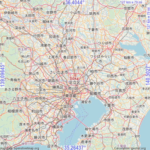
| Upper-left | 36.4044°, | 139.09645° |
| Center: | 35.83643°, | 139.79957° |
| Lower-right: | 35.26437°, | 140.5027° |
| Map W x H: | 126.8×126.8 km | = 78.8×78.8mi |
| max Lat: | 45.40944° ⇑36.8% North |
| Sōka: | 35.83643° |
| min Lat: | ⇓63.2% South 24.34478° |
| min Long | Sōka | max Long |
| 123° | 139.79957° | 145.575° |
| W 74.5%⇐ | ⇒25.5% E |
Elevation
Elevation of Sōka is 6 m = 20 ft, and this is 78.6 m = 258 ft below average elevation for this country.
| Max E: |
1086 m = 3563 ft | 86% |
| Avg. | 84.6 m = 278 ft | |
| Sōka | 6 m = 20 ft | |
Min E: |
-2 m = -7 ft | 14% |
See also: Sōka elevation on elevation.city.
Geographical zone
Sōka is located in North temperate zone (between Tropic of Cancer and the Arctic Circle). Distance of this Northern Tropic circle is 1378.7 km =856.7 mi to South.| Distance of | km | miles | from Sōka |
|---|---|---|---|
| North Pole | 6022.4 | 3742.1 | to North |
| Arctic Circle | 3416.5 | 2122.9 | to North |
| Tropic Cancer | 1378.7 | 856.7 | to South |
| Equator | 3984.6 | 2475.9 | to South |


Nearby cities:
15 places around Sōka: (largest is in red/bold)
• Hatogaya-honchō
5.2 km =3.2 mi,  265°
265°
• Ichikawa-minami
15.4 km =9.6 mi,  142°
142°
• Kawaguchi
8.7 km =5.4 mi,  246°
246°
• Koshigaya
6.1 km =3.8 mi,  351°
351°
• Matsudo
11.1 km =6.9 mi,  124°
124°
• Misato
7.6 km =4.7 mi,  83°
83°
• Nagareyama
9.6 km =6 mi, 76°
• Noda
13.9 km =8.6 mi,  26°
26°
• Saitama
15.1 km =9.4 mi,  301°
301°
• Shimotoda
10.6 km =6.6 mi,  256°
256°
• Toda
12.8 km =8 mi, 259°
• Warabi
10.4 km =6.5 mi, 261°
• Yashio
3.9 km =2.4 mi,  113°
113°
• Yono
15.9 km =9.9 mi,  289°
289°
• Yoshikawa
7.3 km =4.5 mi, 31°
Sources, notices
• [Note1] Compared only with cities in Japan existing in our database
• [Src1] Map data: © OpenStreetMap contributors (CC-BY-SA)
• [Src2] Other city data from geonames.org with taken over terms of usage.
• [Src3] Geographical zone / Annual Mean Temperature by Robert A. Rohde @ Wikipedia
