Yoshikawa geodata
Yoshikawa (Saitama) is a seat of a second-order administrative division; located in Japan in Asia/Tokyo (GMT+9) time zone. With population of 60,510 people, there are 323 cities with bigger population in this country. Compared to other cities in Japan, 64.7% of cities are located further ↓South; 75.1% of cities are located further ←West and 93.5% of cities have higher elevation than Yoshikawa. Note1


Yoshikawa GPS coordinates[2]
35° 53' 32.352" North, 139° 50' 30.624" East
| Map corner | latitude | longitude |
|---|---|---|
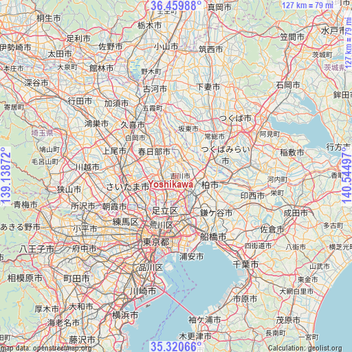
| Upper-left | 36.45988°, | 139.13872° |
| Center: | 35.89232°, | 139.84184° |
| Lower-right: | 35.32066°, | 140.54497° |
| Map W x H: | 126.7×126.7 km | = 78.7×78.7mi |
| max Lat: | 45.40944° ⇑35.3% North |
| Yoshikawa: | 35.89232° |
| min Lat: | ⇓64.7% South 24.34478° |
| min Long | Yoshikawa | max Long |
| 123° | 139.84184° | 145.575° |
| W 75.1%⇐ | ⇒24.9% E |
Elevation
Elevation of Yoshikawa is 4 m = 13 ft, and this is 80.6 m = 264 ft below average elevation for this country.
| Max E: |
1086 m = 3563 ft | 93.5% |
| Avg. | 84.6 m = 278 ft | |
| Yoshikawa | 4 m = 13 ft | |
Min E: |
-2 m = -7 ft | 6.5% |
See also: Yoshikawa elevation on elevation.city.
Geographical zone
Yoshikawa is located in North temperate zone (between Tropic of Cancer and the Arctic Circle). Distance of this Northern Tropic circle is 1384.9 km =860.5 mi to South.| Distance of | km | miles | from Yoshikawa |
|---|---|---|---|
| North Pole | 6016.2 | 3738.3 | to North |
| Arctic Circle | 3410.3 | 2119.1 | to North |
| Tropic Cancer | 1384.9 | 860.5 | to South |
| Equator | 3990.9 | 2479.8 | to South |


Nearby cities:
15 places around Yoshikawa: (largest is in red/bold)
• Abiko
16 km =9.9 mi,  100°
100°
• Hatogaya-honchō
11.1 km =6.9 mi,  233°
233°
• Iwatsuki
15.4 km =9.6 mi,  301°
301°
• Kashiwa
12.7 km =7.9 mi,  105°
105°
• Kasukabe
13.1 km =8.1 mi,  320°
320°
• Kawaguchi
15.3 km =9.5 mi, 230°
• Koshigaya
4.8 km =3 mi,  267°
267°
• Matsudo
13.6 km =8.5 mi,  156°
156°
• Misato
6.6 km =4.1 mi,  145°
145°
• Moriya
15 km =9.3 mi,  72°
72°
• Nagareyama
6.8 km =4.2 mi,  126°
126°
• Noda
6.7 km =4.2 mi,  20°
20°
• Sōka
7.3 km =4.5 mi,  211°
211°
• Warabi
16.1 km =10 mi,  240°
240°
• Yashio
7.8 km =4.8 mi,  181°
181°
Sources, notices
• [Note1] Compared only with cities in Japan existing in our database
• [Src1] Map data: © OpenStreetMap contributors (CC-BY-SA)
• [Src2] Other city data from geonames.org with taken over terms of usage.
• [Src3] Geographical zone / Annual Mean Temperature by Robert A. Rohde @ Wikipedia
