Koshigaya geodata
Koshigaya (Saitama) is a seat of a second-order administrative division; located in Japan in Asia/Tokyo (GMT+9) time zone. With population of 317,437 people, there are 61 cities with bigger population in this country. Compared to other cities in Japan, 64.6% of cities are located further ↓South; 74.4% of cities are located further ←West and 81.8% of cities have higher elevation than Koshigaya. Note1


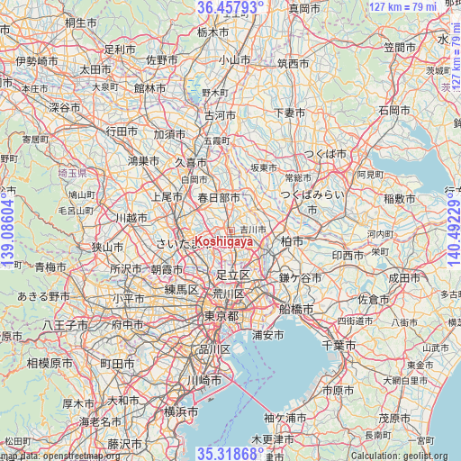
Koshigaya GPS coordinates[2]
35° 53' 25.26" North, 139° 47' 20.976" East
| Map corner | latitude | longitude |
|---|---|---|
| Upper-left | 36.45793°, | 139.08604° |
| Center: | 35.89035°, | 139.78916° |
| Lower-right: | 35.31868°, | 140.49229° |
| Map W x H: | 126.7×126.7 km | = 78.7×78.7mi |
| max Lat: | 45.40944° ⇑35.4% North |
| Koshigaya: | 35.89035° |
| min Lat: | ⇓64.6% South 24.34478° |
| min Long | Koshigaya | max Long |
| 123° | 139.78916° | 145.575° |
| W 74.4%⇐ | ⇒25.6% E |
Elevation
Elevation of Koshigaya is 7 m = 23 ft, and this is 77.6 m = 255 ft below average elevation for this country.
| Max E: |
1086 m = 3563 ft | 81.8% |
| Avg. | 84.6 m = 278 ft | |
| Koshigaya | 7 m = 23 ft | |
Min E: |
-2 m = -7 ft | 18.2% |
See also: Koshigaya elevation on elevation.city.
Geographical zone
Koshigaya is located in North temperate zone (between Tropic of Cancer and the Arctic Circle). Distance of this Northern Tropic circle is 1384.7 km =860.4 mi to South.| Distance of | km | miles | from Koshigaya |
|---|---|---|---|
| North Pole | 6016.4 | 3738.4 | to North |
| Arctic Circle | 3410.5 | 2119.2 | to North |
| Tropic Cancer | 1384.7 | 860.4 | to South |
| Equator | 3990.6 | 2479.6 | to South |


Nearby cities:
15 places around Koshigaya: (largest is in red/bold)
• Hatogaya-honchō
7.6 km =4.7 mi,  213°
213°
• Iwatsuki
11.8 km =7.3 mi,  314°
314°
• Kasukabe
10.9 km =6.8 mi,  340°
340°
• Kawaguchi
11.8 km =7.3 mi,  216°
216°
• Misato
10 km =6.2 mi,  121°
121°
• Nagareyama
10.9 km =6.8 mi,  110°
110°
• Noda
9.6 km =6 mi,  47°
47°
• Saitama
12.1 km =7.5 mi,  279°
279°
• Shimotoda
12.6 km =7.8 mi,  228°
228°
• Sōka
6.1 km =3.8 mi,  171°
171°
• Toda
14.4 km =8.9 mi, 234°
• Warabi
12.1 km =7.5 mi, 230°
• Yashio
8.8 km =5.5 mi,  149°
149°
• Yono
14.1 km =8.8 mi,  266°
266°
• Yoshikawa
4.8 km =3 mi,  87°
87°
Sources, notices
• [Note1] Compared only with cities in Japan existing in our database
• [Src1] Map data: © OpenStreetMap contributors (CC-BY-SA)
• [Src2] Other city data from geonames.org with taken over terms of usage.
• [Src3] Geographical zone / Annual Mean Temperature by Robert A. Rohde @ Wikipedia
