Saitama geodata
Saitama is a seat of a first-order administrative division; located in Japan in Asia/Tokyo (GMT+9) time zone. With population of 1,193,350 people, there are 9 cities with bigger population in this country. Compared to other cities in Japan, 65.2% of cities are located further ↓South; 72.5% of cities are located further ←West and 63.7% of cities have higher elevation than Saitama. Note1


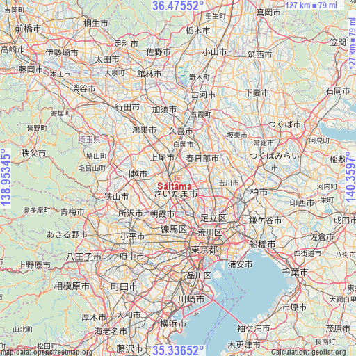
Saitama GPS coordinates[2]
35° 54' 29.052" North, 139° 39' 23.652" East
| Map corner | latitude | longitude |
|---|---|---|
| Upper-left | 36.47552°, | 138.95345° |
| Center: | 35.90807°, | 139.65657° |
| Lower-right: | 35.33652°, | 140.3597° |
| Map W x H: | 126.6×126.6 km | = 78.7×78.7mi |
| max Lat: | 45.40944° ⇑34.8% North |
| Saitama: | 35.90807° |
| min Lat: | ⇓65.2% South 24.34478° |
| min Long | Saitama | max Long |
| 123° | 139.65657° | 145.575° |
| W 72.5%⇐ | ⇒27.5% E |
Elevation
Elevation of Saitama is 16 m = 52 ft, and this is 68.6 m = 225 ft below average elevation for this country.
| Max E: |
1086 m = 3563 ft | 63.7% |
| Avg. | 84.6 m = 278 ft | |
| Saitama | 16 m = 52 ft | |
Min E: |
-2 m = -7 ft | 36.3% |
See also: Saitama elevation on elevation.city.
Geographical zone
Saitama is located in North temperate zone (between Tropic of Cancer and the Arctic Circle). Distance of this Northern Tropic circle is 1386.7 km =861.7 mi to South.| Distance of | km | miles | from Saitama |
|---|---|---|---|
| North Pole | 6014.5 | 3737.2 | to North |
| Arctic Circle | 3408.6 | 2118 | to North |
| Tropic Cancer | 1386.7 | 861.7 | to South |
| Equator | 3992.6 | 2480.9 | to South |


Nearby cities:
15 places around Saitama: (largest is in red/bold)
• Ageoshimo
8 km =5 mi,  331°
331°
• Asaka
12.5 km =7.8 mi,  203°
203°
• Fujimi
11.3 km =7 mi,  233°
233°
• Hasuda
7 km =4.3 mi,  354°
354°
• Hatogaya-honchō
11.4 km =7.1 mi,  137°
137°
• Iwatsuki
7.3 km =4.5 mi,  29°
29°
• Kasukabe
11.8 km =7.3 mi,  45°
45°
• Kawaguchi
12.4 km =7.7 mi,  156°
156°
• Koshigaya
12.1 km =7.5 mi,  99°
99°
• Shiki
10.6 km =6.6 mi,  218°
218°
• Shimotoda
10.7 km =6.6 mi,  165°
165°
• Shiraoka
12.3 km =7.6 mi,  1°
1°
• Toda
10.4 km =6.5 mi,  178°
178°
• Warabi
9.9 km =6.2 mi, 164°
• Yono
3.5 km =2.2 mi, 217°
Sources, notices
• [Note1] Compared only with cities in Japan existing in our database
• [Src1] Map data: © OpenStreetMap contributors (CC-BY-SA)
• [Src2] Other city data from geonames.org with taken over terms of usage.
• [Src3] Geographical zone / Annual Mean Temperature by Robert A. Rohde @ Wikipedia
