Noda geodata
Noda (Chiba) is a seat of a second-order administrative division; located in Japan in Asia/Tokyo (GMT+9) time zone. With population of 121,411 people, there are 175 cities with bigger population in this country. Compared to other cities in Japan, 66% of cities are located further ↓South; 75.8% of cities are located further ←West and 62.8% of cities have higher elevation than Noda. Note1


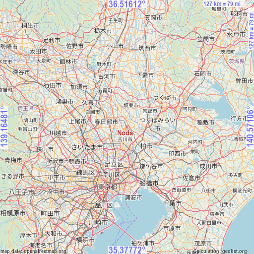
Noda GPS coordinates[2]
35° 56' 56.292" North, 139° 52' 4.548" East
| Map corner | latitude | longitude |
|---|---|---|
| Upper-left | 36.51612°, | 139.16481° |
| Center: | 35.94897°, | 139.86793° |
| Lower-right: | 35.37772°, | 140.57106° |
| Map W x H: | 126.6×126.6 km | = 78.7×78.7mi |
| max Lat: | 45.40944° ⇑34% North |
| Noda: | 35.94897° |
| min Lat: | ⇓66% South 24.34478° |
| min Long | Noda | max Long |
| 123° | 139.86793° | 145.575° |
| W 75.8%⇐ | ⇒24.2% E |
Elevation
Elevation of Noda is 17 m = 56 ft, and this is 67.6 m = 222 ft below average elevation for this country.
| Max E: |
1086 m = 3563 ft | 62.8% |
| Avg. | 84.6 m = 278 ft | |
| Noda | 17 m = 56 ft | |
Min E: |
-2 m = -7 ft | 37.2% |
See also: Noda elevation on elevation.city.
Geographical zone
Noda is located in North temperate zone (between Tropic of Cancer and the Arctic Circle). Distance of this Northern Tropic circle is 1391.2 km =864.5 mi to South.| Distance of | km | miles | from Noda |
|---|---|---|---|
| North Pole | 6009.9 | 3734.4 | to North |
| Arctic Circle | 3404 | 2115.1 | to North |
| Tropic Cancer | 1391.2 | 864.5 | to South |
| Equator | 3997.2 | 2483.7 | to South |


Nearby cities:
15 places around Noda: (largest is in red/bold)
• Bandō
13.5 km =8.4 mi,  359°
359°
• Iwai
11.6 km =7.2 mi,  14°
14°
• Iwatsuki
15.5 km =9.6 mi,  276°
276°
• Jōsō
12.8 km =8 mi,  41°
41°
• Kashiwa
13.8 km =8.6 mi,  134°
134°
• Kasukabe
11.3 km =7 mi,  289°
289°
• Koshigaya
9.6 km =6 mi,  227°
227°
• Misato
11.8 km =7.3 mi,  173°
173°
• Mitsukaidō
12.8 km =8 mi,  54°
54°
• Moriya
12 km =7.5 mi,  98°
98°
• Nagareyama
10.8 km =6.7 mi,  163°
163°
• Sōka
13.9 km =8.6 mi,  206°
206°
• Tsukubamirai
13.3 km =8.3 mi,  72°
72°
• Yashio
14.3 km =8.9 mi,  190°
190°
• Yoshikawa
6.7 km =4.2 mi,  200°
200°
Sources, notices
• [Note1] Compared only with cities in Japan existing in our database
• [Src1] Map data: © OpenStreetMap contributors (CC-BY-SA)
• [Src2] Other city data from geonames.org with taken over terms of usage.
• [Src3] Geographical zone / Annual Mean Temperature by Robert A. Rohde @ Wikipedia
