Miyama geodata
Miyama (Fukuoka) is a seat of a second-order administrative division; located in Japan in Asia/Tokyo (GMT+9) time zone. In our database, there are 767 cities with bigger population. Compared to other cities in Japan, 90% of cities are located further ↑North; 92.5% of cities are located further →East and 76.3% of cities have higher elevation than Miyama. Note1


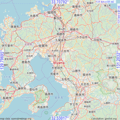
Miyama GPS coordinates[2]
33° 7' 15.672" North, 130° 30' 0.252" East
| Map corner | latitude | longitude |
|---|---|---|
| Upper-left | 33.70792°, | 129.79695° |
| Center: | 33.12102°, | 130.50007° |
| Lower-right: | 32.53017°, | 131.2032° |
| Map W x H: | 131×131 km | = 81.4×81.4mi |
| max Lat: | 45.40944° ⇑90% North |
| Miyama: | 33.12102° |
| min Lat: | ⇓10% South 24.34478° |
| min Long | Miyama | max Long |
| 123° | 130.50007° | 145.575° |
| W 7.5%⇐ | ⇒92.5% E |
Elevation
Elevation of Miyama is 9 m = 30 ft, and this is 75.6 m = 248 ft below average elevation for this country.
| Max E: |
1086 m = 3563 ft | 76.3% |
| Avg. | 84.6 m = 278 ft | |
| Miyama | 9 m = 30 ft | |
Min E: |
-2 m = -7 ft | 23.7% |
See also: Japan elevation on elevation.city.
Geographical zone
Miyama is located in North temperate zone (between Tropic of Cancer and the Arctic Circle). Distance of this Northern Tropic circle is 1076.8 km =669.1 mi to South.| Distance of | km | miles | from Miyama |
|---|---|---|---|
| North Pole | 6324.3 | 3929.7 | to North |
| Arctic Circle | 3718.5 | 2310.6 | to North |
| Tropic Cancer | 1076.8 | 669.1 | to South |
| Equator | 3682.7 | 2288.3 | to South |


Nearby cities:
15 places around Miyama: (largest is in red/bold)
• Arao
16.6 km =10.3 mi,  197°
197°
• Chikugo
9.4 km =5.8 mi,  355°
355°
• Kanzaki
27 km =16.8 mi,  326°
326°
• Kanzakimachi-kanzaki
24 km =14.9 mi, 330°
• Kurume
21.8 km =13.5 mi,  4°
4°
• Ogōri
30 km =18.6 mi,  8°
8°
• Saga
22.4 km =13.9 mi,  303°
303°
• Setakamachi-takayanagi
4.4 km =2.7 mi,  313°
313°
• Tamana
20.5 km =12.7 mi,  160°
160°
• Tosu
27.4 km =17 mi, 3°
• Yamaga
21.1 km =13.1 mi,  123°
123°
• Yame
18.2 km =11.3 mi,  49°
49°
• Yanagawa
10.6 km =6.6 mi, 298°
• Ōkawa
15 km =9.3 mi, 309°
• Ōmuta
10.8 km =6.7 mi,  205°
205°
Sources, notices
• [Note1] Compared only with cities in Japan existing in our database
• [Src1] Map data: © OpenStreetMap contributors (CC-BY-SA)
• [Src2] Other city data from geonames.org with taken over terms of usage.
• [Src3] Geographical zone / Annual Mean Temperature by Robert A. Rohde @ Wikipedia
