Setakamachi-takayanagi geodata
Setakamachi-takayanagi (Fukuoka) is a populated place; located in Japan in Asia/Tokyo (GMT+9) time zone. With population of 23,985 people, there are 622 cities with bigger population in this country. Compared to other cities in Japan, 89.7% of cities are located further ↑North; 93.1% of cities are located further →East and 89.6% of cities have higher elevation than Setakamachi-takayanagi. Note1
Current local time in Setakamachi-takayanagi:
01:28 AM, ThursdayDifference from your time zone: hours


Setakamachi-takayanagi GPS coordinates[2]
33° 8' 54.888" North, 130° 27' 55.728" East
| Map corner | latitude | longitude |
|---|---|---|
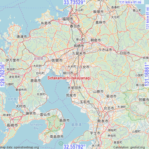
| Upper-left | 33.73529°, | 129.76236° |
| Center: | 33.14858°, | 130.46548° |
| Lower-right: | 32.55792°, | 131.16861° |
| Map W x H: | 130.9×130.9 km | = 81.3×81.3mi |
| max Lat: | 45.40944° ⇑89.7% North |
| Setakamachi-takayanagi: | 33.14858° |
| min Lat: | ⇓10.3% South 24.34478° |
| min Long | Setakamachi-tak | max Long |
| 123° | 130.46548° | 145.575° |
| W 6.9%⇐ | ⇒93.1% E |
Elevation
Elevation of Setakamachi-takayanagi is 5 m = 16 ft, and this is 79.6 m = 261 ft below average elevation for this country.
| Max E: |
1086 m = 3563 ft | 89.6% |
| Avg. | 84.6 m = 278 ft | |
| Setakamachi-takayanagi | 5 m = 16 ft | |
Min E: |
-2 m = -7 ft | 10.4% |
See also: Japan elevation on elevation.city.
Geographical zone
Setakamachi-takayanagi is located in North temperate zone (between Tropic of Cancer and the Arctic Circle). Distance of this Northern Tropic circle is 1079.9 km =671 mi to South.| Distance of | km | miles | from Setakamachi-takayanagi |
|---|---|---|---|
| North Pole | 6321.3 | 3927.9 | to North |
| Arctic Circle | 3715.4 | 2308.6 | to North |
| Tropic Cancer | 1079.9 | 671 | to South |
| Equator | 3685.8 | 2290.2 | to South |


Nearby cities:
15 places around Setakamachi-takayanagi: (largest is in red/bold)
• Arao
19 km =11.8 mi,  185°
185°
• Chikugo
6.8 km =4.2 mi,  21°
21°
• Kanzaki
22.7 km =14.1 mi,  329°
329°
• Kanzakimachi-kanzaki
19.8 km =12.3 mi, 334°
• Kurume
19.3 km =12 mi,  14°
14°
• Miyama
4.4 km =2.7 mi,  133°
133°
• Ogōri
27.7 km =17.2 mi, 16°
• Saga
18.1 km =11.2 mi,  301°
301°
• Tamana
24.6 km =15.3 mi,  155°
155°
• Tosu
24.7 km =15.3 mi, 11°
• Yamaga
25.5 km =15.8 mi, 125°
• Yame
19.2 km =11.9 mi,  62°
62°
• Yanagawa
6.4 km =4 mi,  288°
288°
• Ōkawa
10.5 km =6.5 mi,  307°
307°
• Ōmuta
12.9 km =8 mi, 186°
Sources, notices
• [Note1] Compared only with cities in Japan existing in our database
• [Src1] Map data: © OpenStreetMap contributors (CC-BY-SA)
• [Src2] Other city data from geonames.org with taken over terms of usage.
• [Src3] Geographical zone / Annual Mean Temperature by Robert A. Rohde @ Wikipedia
