Nōgata geodata
Nōgata (Fukuoka) is a seat of a second-order administrative division; located in Japan in Asia/Tokyo (GMT+9) time zone. With population of 56,821 people, there are 342 cities with bigger population in this country. Compared to other cities in Japan, 82.6% of cities are located further ↑North; 89.2% of cities are located further →East and 52.3% of cities have higher elevation than Nōgata. Note1


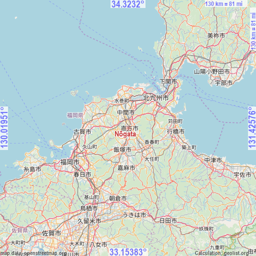
Nōgata GPS coordinates[2]
33° 44' 25.836" North, 130° 43' 21.468" East
| Map corner | latitude | longitude |
|---|---|---|
| Upper-left | 34.3232°, | 130.01951° |
| Center: | 33.74051°, | 130.72263° |
| Lower-right: | 33.15383°, | 131.42576° |
| Map W x H: | 130×130 km | = 80.8×80.8mi |
| max Lat: | 45.40944° ⇑82.6% North |
| Nōgata: | 33.74051° |
| min Lat: | ⇓17.4% South 24.34478° |
| min Long | Nōgata | max Long |
| 123° | 130.72263° | 145.575° |
| W 10.8%⇐ | ⇒89.2% E |
Elevation
Elevation of Nōgata is 26 m = 85 ft, and this is 58.6 m = 192 ft below average elevation for this country.
| Max E: |
1086 m = 3563 ft | 52.3% |
| Avg. | 84.6 m = 278 ft | |
| Nōgata | 26 m = 85 ft | |
Min E: |
-2 m = -7 ft | 47.7% |
See also: Nōgata elevation on elevation.city.
Geographical zone
Nōgata is located in North temperate zone (between Tropic of Cancer and the Arctic Circle). Distance of this Northern Tropic circle is 1145.7 km =711.9 mi to South.| Distance of | km | miles | from Nōgata |
|---|---|---|---|
| North Pole | 6255.5 | 3887 | to North |
| Arctic Circle | 3649.6 | 2267.8 | to North |
| Tropic Cancer | 1145.7 | 711.9 | to South |
| Equator | 3751.6 | 2331.1 | to South |


Nearby cities:
15 places around Nōgata: (largest is in red/bold)
• Fukutsu
21.9 km =13.6 mi,  282°
282°
• Iizuka
12 km =7.5 mi,  196°
196°
• Kama
22.9 km =14.2 mi,  175°
175°
• Kanda
24.6 km =15.3 mi,  78°
78°
• Kawasaki
17.8 km =11.1 mi,  151°
151°
• Kitakyushu
17.1 km =10.6 mi,  43°
43°
• Koga
23.7 km =14.7 mi,  268°
268°
• Miyata
7.4 km =4.6 mi,  240°
240°
• Miyawaka
8 km =5 mi,  250°
250°
• Munakata
16.3 km =10.1 mi,  292°
292°
• Nakama
8.6 km =5.3 mi,  351°
351°
• Nishifukuma
23.1 km =14.4 mi, 277°
• Sasaguri
21.1 km =13.1 mi,  228°
228°
• Tagawa
13.9 km =8.6 mi, 149°
• Yukuhashi
24.1 km =15 mi,  93°
93°
Sources, notices
• [Note1] Compared only with cities in Japan existing in our database
• [Src1] Map data: © OpenStreetMap contributors (CC-BY-SA)
• [Src2] Other city data from geonames.org with taken over terms of usage.
• [Src3] Geographical zone / Annual Mean Temperature by Robert A. Rohde @ Wikipedia
