Miyawaka geodata
Miyawaka (Fukuoka) is a seat of a second-order administrative division; located in Japan in Asia/Tokyo (GMT+9) time zone. In our database, there are 767 cities with bigger population. Compared to other cities in Japan, 83% of cities are located further ↑North; 90.9% of cities are located further →East and 83% of cities have lower elevation than Miyawaka. Note1


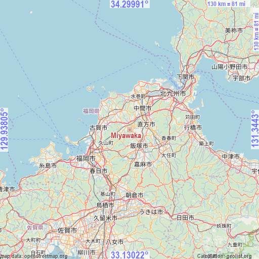
Miyawaka GPS coordinates[2]
33° 43' 1.416" North, 130° 38' 28.212" East
| Map corner | latitude | longitude |
|---|---|---|
| Upper-left | 34.29991°, | 129.93805° |
| Center: | 33.71706°, | 130.64117° |
| Lower-right: | 33.13022°, | 131.3443° |
| Map W x H: | 130.1×130.1 km | = 80.8×80.8mi |
| max Lat: | 45.40944° ⇑83% North |
| Miyawaka: | 33.71706° |
| min Lat: | ⇓17% South 24.34478° |
| min Long | Miyawaka | max Long |
| 123° | 130.64117° | 145.575° |
| W 9.1%⇐ | ⇒90.9% E |
Elevation
Elevation of Miyawaka is 152 m = 499 ft, and this is 67.4 m = 221 ft above average elevation for this country.
| Max E: |
1086 m = 3563 ft | 17% |
| Miyawaka | 152 m 499 ft | |
| Avg. | 84.6 m = 278 ft | |
Min E: |
-2 m = -7 ft | 83% |
See also: Japan elevation on elevation.city.
Geographical zone
Miyawaka is located in North temperate zone (between Tropic of Cancer and the Arctic Circle). Distance of this Northern Tropic circle is 1143.1 km =710.3 mi to South.| Distance of | km | miles | from Miyawaka |
|---|---|---|---|
| North Pole | 6258.1 | 3888.6 | to North |
| Arctic Circle | 3652.2 | 2269.4 | to North |
| Tropic Cancer | 1143.1 | 710.3 | to South |
| Equator | 3749 | 2329.5 | to South |


Nearby cities:
15 places around Miyawaka: (largest is in red/bold)
• Fukutsu
15.7 km =9.8 mi,  297°
297°
• Iizuka
9.9 km =6.2 mi,  154°
154°
• Kama
22.3 km =13.9 mi,  155°
155°
• Kawasaki
20.7 km =12.9 mi,  128°
128°
• Kitakyushu
24.5 km =15.2 mi,  52°
52°
• Koga
16.2 km =10.1 mi,  276°
276°
• Miyata
1.5 km =0.9 mi, 132°
• Munakata
11.6 km =7.2 mi,  319°
319°
• Nakama
12.8 km =8 mi,  29°
29°
• Nishifukuma
16.3 km =10.1 mi,  289°
289°
• Nōgata
8 km =5 mi,  70°
70°
• Sasaguri
14 km =8.7 mi,  216°
216°
• Shingū
19.4 km =12.1 mi,  268°
268°
• Tagawa
17.4 km =10.8 mi,  122°
122°
• Umi
20.5 km =12.7 mi, 216°
Sources, notices
• [Note1] Compared only with cities in Japan existing in our database
• [Src1] Map data: © OpenStreetMap contributors (CC-BY-SA)
• [Src2] Other city data from geonames.org with taken over terms of usage.
• [Src3] Geographical zone / Annual Mean Temperature by Robert A. Rohde @ Wikipedia
