Miyoshi geodata
Miyoshi (Hiroshima) is a seat of a second-order administrative division; located in Japan in Asia/Tokyo (GMT+9) time zone. With population of 39,257 people, there are 459 cities with bigger population in this country. Compared to other cities in Japan, 64.9% of cities are located further ↑North; 80% of cities are located further →East and 83.3% of cities have lower elevation than Miyoshi. Note1


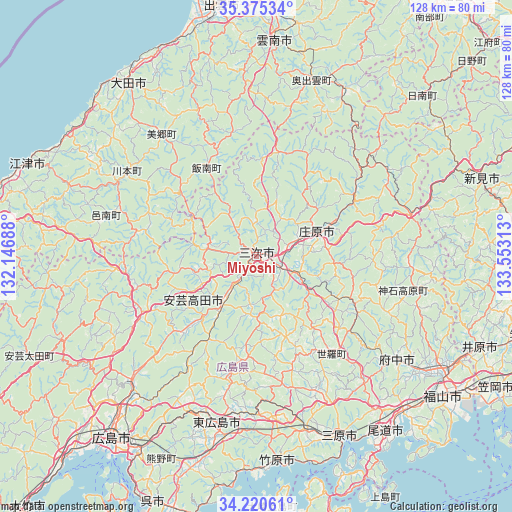
Miyoshi GPS coordinates[2]
34° 48' 0" North, 132° 51' 0" East
| Map corner | latitude | longitude |
|---|---|---|
| Upper-left | 35.37534°, | 132.14688° |
| Center: | 34.8°, | 132.85° |
| Lower-right: | 34.22061°, | 133.55313° |
| Map W x H: | 128.4×128.4 km | = 79.8×79.8mi |
| max Lat: | 45.40944° ⇑64.9% North |
| Miyoshi: | 34.8° |
| min Lat: | ⇓35.1% South 24.34478° |
| min Long | Miyoshi | max Long |
| 123° | 132.85° | 145.575° |
| W 20%⇐ | ⇒80% E |
Elevation
Elevation of Miyoshi is 154 m = 505 ft, and this is 69.4 m = 228 ft above average elevation for this country.
| Max E: |
1086 m = 3563 ft | 16.7% |
| Miyoshi | 154 m 505 ft | |
| Avg. | 84.6 m = 278 ft | |
Min E: |
-2 m = -7 ft | 83.3% |
See also: Japan elevation on elevation.city.
Geographical zone
Miyoshi is located in North temperate zone (between Tropic of Cancer and the Arctic Circle). Distance of this Northern Tropic circle is 1263.5 km =785.1 mi to South.| Distance of | km | miles | from Miyoshi |
|---|---|---|---|
| North Pole | 6137.7 | 3813.8 | to North |
| Arctic Circle | 3531.8 | 2194.6 | to North |
| Tropic Cancer | 1263.5 | 785.1 | to South |
| Equator | 3869.4 | 2404.3 | to South |


Nearby cities:
15 places around Miyoshi: (largest is in red/bold)
• Aki-takata
20.8 km =12.9 mi,  227°
227°
• Fuchūchō
43.3 km =26.9 mi,  125°
125°
• Fukuyama
58.9 km =36.6 mi, 126°
• Higashihiroshima
44.7 km =27.8 mi,  193°
193°
• Hiroshima
57.6 km =35.8 mi,  219°
219°
• Kannabechō-yahiro
58.5 km =36.4 mi,  117°
117°
• Mihara
49.3 km =30.6 mi,  154°
154°
• Niimi
59.8 km =37.2 mi,  70°
70°
• Oda
54.8 km =34.1 mi,  324°
324°
• Onomichi
53.3 km =33.1 mi,  143°
143°
• Shin’ichi
47.3 km =29.4 mi, 125°
• Shōbara
16.2 km =10.1 mi, 69°
• Takehara
51.7 km =32.1 mi,  173°
173°
• Unnan
49.5 km =30.8 mi,  5°
5°
• Ōdachō-ōda
53.4 km =33.2 mi, 324°
Sources, notices
• [Note1] Compared only with cities in Japan existing in our database
• [Src1] Map data: © OpenStreetMap contributors (CC-BY-SA)
• [Src2] Other city data from geonames.org with taken over terms of usage.
• [Src3] Geographical zone / Annual Mean Temperature by Robert A. Rohde @ Wikipedia
