Mihara geodata
Mihara (Hiroshima) is a seat of a second-order administrative division; located in Japan in Asia/Tokyo (GMT+9) time zone. With population of 80,387 people, there are 253 cities with bigger population in this country. Compared to other cities in Japan, 74.4% of cities are located further ↑North; 79.1% of cities are located further →East and 71.1% of cities have higher elevation than Mihara. Note1


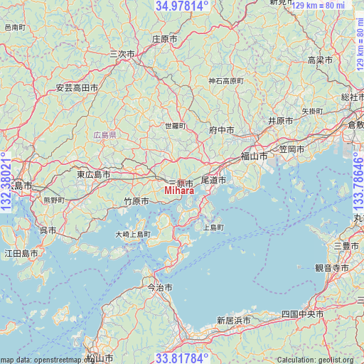
Mihara GPS coordinates[2]
34° 24' 0" North, 133° 4' 59.988" East
| Map corner | latitude | longitude |
|---|---|---|
| Upper-left | 34.97814°, | 132.38021° |
| Center: | 34.4°, | 133.08333° |
| Lower-right: | 33.81784°, | 133.78646° |
| Map W x H: | 129×129 km | = 80.2×80.2mi |
| max Lat: | 45.40944° ⇑74.4% North |
| Mihara: | 34.4° |
| min Lat: | ⇓25.6% South 24.34478° |
| min Long | Mihara | max Long |
| 123° | 133.08333° | 145.575° |
| W 20.9%⇐ | ⇒79.1% E |
Elevation
Elevation of Mihara is 11 m = 36 ft, and this is 73.6 m = 241 ft below average elevation for this country.
| Max E: |
1086 m = 3563 ft | 71.1% |
| Avg. | 84.6 m = 278 ft | |
| Mihara | 11 m = 36 ft | |
Min E: |
-2 m = -7 ft | 28.9% |
See also: Mihara elevation on elevation.city.
Geographical zone
Mihara is located in North temperate zone (between Tropic of Cancer and the Arctic Circle). Distance of this Northern Tropic circle is 1219 km =757.5 mi to South.| Distance of | km | miles | from Mihara |
|---|---|---|---|
| North Pole | 6182.1 | 3841.4 | to North |
| Arctic Circle | 3576.3 | 2222.2 | to North |
| Tropic Cancer | 1219 | 757.5 | to South |
| Equator | 3824.9 | 2376.7 | to South |


Nearby cities:
15 places around Mihara: (largest is in red/bold)
• Aki-takata
47.8 km =29.7 mi,  309°
309°
• Asakuchi
49.9 km =31 mi,  72°
72°
• Fuchūchō
23.8 km =14.8 mi,  35°
35°
• Fukuyama
27.6 km =17.1 mi, 70°
• Higashihiroshima
31.8 km =19.8 mi,  271°
271°
• Ibara
41.6 km =25.8 mi,  57°
57°
• Imabari-shi
37.5 km =23.3 mi,  191°
191°
• Innoshima
15.9 km =9.9 mi,  144°
144°
• Kamogatachō-kamogata
48.9 km =30.4 mi, 71°
• Kannabechō-yahiro
35.4 km =22 mi, 60°
• Kasaoka
40.3 km =25 mi, 73°
• Miyoshi
49.3 km =30.6 mi,  334°
334°
• Onomichi
10.9 km =6.8 mi,  80°
80°
• Shin’ichi
24.5 km =15.2 mi,  45°
45°
• Takehara
16.8 km =10.4 mi,  245°
245°
Sources, notices
• [Note1] Compared only with cities in Japan existing in our database
• [Src1] Map data: © OpenStreetMap contributors (CC-BY-SA)
• [Src2] Other city data from geonames.org with taken over terms of usage.
• [Src3] Geographical zone / Annual Mean Temperature by Robert A. Rohde @ Wikipedia
