Takehara geodata
Takehara (Hiroshima) is a seat of a second-order administrative division; located in Japan in Asia/Tokyo (GMT+9) time zone. With population of 30,506 people, there are 545 cities with bigger population in this country. Compared to other cities in Japan, 75.2% of cities are located further ↑North; 79.6% of cities are located further →East and 60.4% of cities have higher elevation than Takehara. Note1


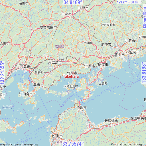
Takehara GPS coordinates[2]
34° 20' 17.988" North, 132° 55' 0.012" East
| Map corner | latitude | longitude |
|---|---|---|
| Upper-left | 34.9169°, | 132.21355° |
| Center: | 34.33833°, | 132.91667° |
| Lower-right: | 33.75574°, | 133.6198° |
| Map W x H: | 129.1×129.1 km | = 80.2×80.2mi |
| max Lat: | 45.40944° ⇑75.2% North |
| Takehara: | 34.33833° |
| min Lat: | ⇓24.8% South 24.34478° |
| min Long | Takehara | max Long |
| 123° | 132.91667° | 145.575° |
| W 20.4%⇐ | ⇒79.6% E |
Elevation
Elevation of Takehara is 19 m = 62 ft, and this is 65.6 m = 215 ft below average elevation for this country.
| Max E: |
1086 m = 3563 ft | 60.4% |
| Avg. | 84.6 m = 278 ft | |
| Takehara | 19 m = 62 ft | |
Min E: |
-2 m = -7 ft | 39.6% |
See also: Japan elevation on elevation.city.
Geographical zone
Takehara is located in North temperate zone (between Tropic of Cancer and the Arctic Circle). Distance of this Northern Tropic circle is 1212.1 km =753.2 mi to South.| Distance of | km | miles | from Takehara |
|---|---|---|---|
| North Pole | 6189 | 3845.7 | to North |
| Arctic Circle | 3583.1 | 2226.4 | to North |
| Tropic Cancer | 1212.1 | 753.2 | to South |
| Equator | 3818.1 | 2372.5 | to South |


Nearby cities:
15 places around Takehara: (largest is in red/bold)
• Aki-takata
43.1 km =26.8 mi,  330°
330°
• Etajima
41.6 km =25.8 mi,  254°
254°
• Fuchūchō
39.2 km =24.4 mi,  48°
48°
• Fukuyama
44.3 km =27.5 mi,  68°
68°
• Higashihiroshima
18.3 km =11.4 mi,  295°
295°
• Hiroshima
43.4 km =27 mi,  279°
279°
• Hōjō
42.2 km =26.2 mi,  197°
197°
• Imabari-shi
30.8 km =19.1 mi,  165°
165°
• Innoshima
25.2 km =15.7 mi,  104°
104°
• Kannabechō-yahiro
52.1 km =32.4 mi,  62°
62°
• Kure
34.3 km =21.3 mi, 249°
• Mihara
16.8 km =10.4 mi, 65°
• Miyoshi
51.7 km =32.1 mi,  353°
353°
• Onomichi
27.4 km =17 mi, 71°
• Shin’ichi
40.6 km =25.2 mi, 53°
Sources, notices
• [Note1] Compared only with cities in Japan existing in our database
• [Src1] Map data: © OpenStreetMap contributors (CC-BY-SA)
• [Src2] Other city data from geonames.org with taken over terms of usage.
• [Src3] Geographical zone / Annual Mean Temperature by Robert A. Rohde @ Wikipedia
