Neyagawa geodata
Neyagawa (Ōsaka) is a seat of a second-order administrative division; located in Japan in Asia/Tokyo (GMT+9) time zone. With population of 238,549 people, there are 87 cities with bigger population in this country. Compared to other cities in Japan, 66.2% of cities are located further ↑North; 65% of cities are located further →East and 76.3% of cities have higher elevation than Neyagawa. Note1


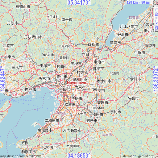
Neyagawa GPS coordinates[2]
34° 45' 58.14" North, 135° 37' 39.324" East
| Map corner | latitude | longitude |
|---|---|---|
| Upper-left | 35.34173°, | 134.92447° |
| Center: | 34.76615°, | 135.62759° |
| Lower-right: | 34.18653°, | 136.33072° |
| Map W x H: | 128.4×128.4 km | = 79.8×79.8mi |
| max Lat: | 45.40944° ⇑66.2% North |
| Neyagawa: | 34.76615° |
| min Lat: | ⇓33.8% South 24.34478° |
| min Long | Neyagawa | max Long |
| 123° | 135.62759° | 145.575° |
| W 35%⇐ | ⇒65% E |
Elevation
Elevation of Neyagawa is 9 m = 30 ft, and this is 75.6 m = 248 ft below average elevation for this country.
| Max E: |
1086 m = 3563 ft | 76.3% |
| Avg. | 84.6 m = 278 ft | |
| Neyagawa | 9 m = 30 ft | |
Min E: |
-2 m = -7 ft | 23.7% |
See also: Neyagawa elevation on elevation.city.
Geographical zone
Neyagawa is located in North temperate zone (between Tropic of Cancer and the Arctic Circle). Distance of this Northern Tropic circle is 1259.7 km =782.7 mi to South.| Distance of | km | miles | from Neyagawa |
|---|---|---|---|
| North Pole | 6141.4 | 3816.1 | to North |
| Arctic Circle | 3535.5 | 2196.9 | to North |
| Tropic Cancer | 1259.7 | 782.7 | to South |
| Equator | 3865.6 | 2402 | to South |


Nearby cities:
15 places around Neyagawa: (largest is in red/bold)
• Daitōchō
5.9 km =3.7 mi,  186°
186°
• Higashi-ōsaka
11.8 km =7.3 mi,  200°
200°
• Hirakata
5.6 km =3.5 mi,  20°
20°
• Ibaraki
7.8 km =4.8 mi,  315°
315°
• Ikoma
11.3 km =7 mi,  144°
144°
• Kadoma
5.8 km =3.6 mi,  237°
237°
• Katano
6.1 km =3.8 mi,  60°
60°
• Kyōtanabe
13.4 km =8.3 mi,  71°
71°
• Moriguchi
6.7 km =4.2 mi, 236°
• Osaka
14 km =8.7 mi,  234°
234°
• Settsu
3.3 km =2.1 mi,  294°
294°
• Shijōnawate
6.3 km =3.9 mi,  125°
125°
• Suita
10.2 km =6.3 mi,  267°
267°
• Takatsuki
9.2 km =5.7 mi,  353°
353°
• Yawata
13.4 km =8.3 mi,  30°
30°
Sources, notices
• [Note1] Compared only with cities in Japan existing in our database
• [Src1] Map data: © OpenStreetMap contributors (CC-BY-SA)
• [Src2] Other city data from geonames.org with taken over terms of usage.
• [Src3] Geographical zone / Annual Mean Temperature by Robert A. Rohde @ Wikipedia
