Takatsuki geodata
Takatsuki (Ōsaka) is a seat of a second-order administrative division; located in Japan in Asia/Tokyo (GMT+9) time zone. With population of 354,468 people, there are 49 cities with bigger population in this country. Compared to other cities in Japan, 62.8% of cities are located further ↑North; 65.2% of cities are located further →East and 66.8% of cities have higher elevation than Takatsuki. Note1


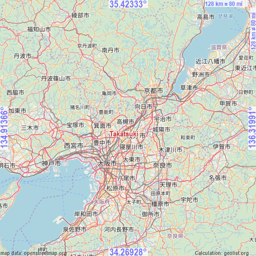
Takatsuki GPS coordinates[2]
34° 50' 53.988" North, 135° 37' 0.408" East
| Map corner | latitude | longitude |
|---|---|---|
| Upper-left | 35.42333°, | 134.91366° |
| Center: | 34.84833°, | 135.61678° |
| Lower-right: | 34.26928°, | 136.31991° |
| Map W x H: | 128.3×128.3 km | = 79.7×79.7mi |
| max Lat: | 45.40944° ⇑62.8% North |
| Takatsuki: | 34.84833° |
| min Lat: | ⇓37.2% South 24.34478° |
| min Long | Takatsuki | max Long |
| 123° | 135.61678° | 145.575° |
| W 34.8%⇐ | ⇒65.2% E |
Elevation
Elevation of Takatsuki is 14 m = 46 ft, and this is 70.6 m = 232 ft below average elevation for this country.
| Max E: |
1086 m = 3563 ft | 66.8% |
| Avg. | 84.6 m = 278 ft | |
| Takatsuki | 14 m = 46 ft | |
Min E: |
-2 m = -7 ft | 33.2% |
See also: Takatsuki elevation on elevation.city.
Geographical zone
Takatsuki is located in North temperate zone (between Tropic of Cancer and the Arctic Circle). Distance of this Northern Tropic circle is 1268.9 km =788.5 mi to South.| Distance of | km | miles | from Takatsuki |
|---|---|---|---|
| North Pole | 6132.3 | 3810.4 | to North |
| Arctic Circle | 3526.4 | 2191.2 | to North |
| Tropic Cancer | 1268.9 | 788.5 | to South |
| Equator | 3874.8 | 2407.7 | to South |


Nearby cities:
15 places around Takatsuki: (largest is in red/bold)
• Daitōchō
15 km =9.3 mi,  178°
178°
• Hirakata
4.9 km =3 mi,  142°
142°
• Ibaraki
5.7 km =3.5 mi,  231°
231°
• Kadoma
12.9 km =8 mi,  197°
197°
• Katano
8.8 km =5.5 mi,  134°
134°
• Kyōtanabe
14.5 km =9 mi,  109°
109°
• Mino
13.6 km =8.5 mi,  259°
259°
• Moriguchi
13.6 km =8.5 mi, 199°
• Nagaoka
11.5 km =7.1 mi,  36°
36°
• Neyagawa
9.2 km =5.7 mi,  173°
173°
• Settsu
8 km =5 mi,  194°
194°
• Shijōnawate
14.2 km =8.8 mi,  154°
154°
• Suita
13.4 km =8.3 mi,  223°
223°
• Tanabe
13.9 km =8.6 mi,  101°
101°
• Yawata
8.2 km =5.1 mi,  72°
72°
Sources, notices
• [Note1] Compared only with cities in Japan existing in our database
• [Src1] Map data: © OpenStreetMap contributors (CC-BY-SA)
• [Src2] Other city data from geonames.org with taken over terms of usage.
• [Src3] Geographical zone / Annual Mean Temperature by Robert A. Rohde @ Wikipedia
