Jōetsu geodata
Jōetsu (Niigata) is a seat of a second-order administrative division; located in Japan in Asia/Tokyo (GMT+9) time zone. With population of 204,137 people, there are 101 cities with bigger population in this country. Compared to other cities in Japan, 82.9% of cities are located further ↓South; 55% of cities are located further ←West and 73.6% of cities have higher elevation than Jōetsu. Note1


Jōetsu GPS coordinates[2]
37° 8' 53.808" North, 138° 14' 11.112" East
| Map corner | latitude | longitude |
|---|---|---|
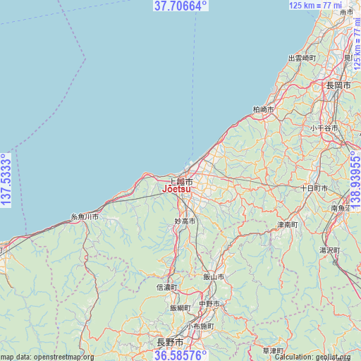
| Upper-left | 37.70664°, | 137.5333° |
| Center: | 37.14828°, | 138.23642° |
| Lower-right: | 36.58576°, | 138.93955° |
| Map W x H: | 124.6×124.6 km | = 77.4×77.4mi |
| max Lat: | 45.40944° ⇑17.1% North |
| Jōetsu: | 37.14828° |
| min Lat: | ⇓82.9% South 24.34478° |
| min Long | Jōetsu | max Long |
| 123° | 138.23642° | 145.575° |
| W 55%⇐ | ⇒45% E |
Elevation
Elevation of Jōetsu is 10 m = 33 ft, and this is 74.6 m = 245 ft below average elevation for this country.
| Max E: |
1086 m = 3563 ft | 73.6% |
| Avg. | 84.6 m = 278 ft | |
| Jōetsu | 10 m = 33 ft | |
Min E: |
-2 m = -7 ft | 26.4% |
See also: Jōetsu elevation on elevation.city.
Geographical zone
Jōetsu is located in North temperate zone (between Tropic of Cancer and the Arctic Circle). Distance of this Northern Tropic circle is 1524.6 km =947.3 mi to South.| Distance of | km | miles | from Jōetsu |
|---|---|---|---|
| North Pole | 5876.6 | 3651.5 | to North |
| Arctic Circle | 3270.7 | 2032.3 | to North |
| Tropic Cancer | 1524.6 | 947.3 | to South |
| Equator | 4130.5 | 2566.6 | to South |


Nearby cities:
15 places around Jōetsu: (largest is in red/bold)
• Arai
16.4 km =10.2 mi,  183°
183°
• Hakuba
60.1 km =37.3 mi,  213°
213°
• Iiyama
35.1 km =21.8 mi,  160°
160°
• Itoigawa
36.6 km =22.7 mi,  249°
249°
• Kashiwazaki
36.9 km =22.9 mi,  48°
48°
• Minamiuonuma
57 km =35.4 mi,  97°
97°
• Muikamachi
58.1 km =36.1 mi, 98°
• Myoko
15.2 km =9.4 mi,  167°
167°
• Nagano
55.6 km =34.5 mi, 184°
• Nagaoka
63.8 km =39.6 mi,  58°
58°
• Nakano
45.8 km =28.5 mi, 165°
• Ojiya
52.7 km =32.7 mi,  71°
71°
• Shiozawa
55.7 km =34.6 mi, 102°
• Suzaka
55.9 km =34.7 mi, 172°
• Tōkamachi
47 km =29.2 mi,  92°
92°
Sources, notices
• [Note1] Compared only with cities in Japan existing in our database
• [Src1] Map data: © OpenStreetMap contributors (CC-BY-SA)
• [Src2] Other city data from geonames.org with taken over terms of usage.
• [Src3] Geographical zone / Annual Mean Temperature by Robert A. Rohde @ Wikipedia
