Arai geodata
Arai (Niigata) is a populated place; located in Japan in Asia/Tokyo (GMT+9) time zone. With population of 27,481 people, there are 575 cities with bigger population in this country. Compared to other cities in Japan, 82% of cities are located further ↓South; 54.9% of cities are located further ←West and 85.4% of cities have lower elevation than Arai. Note1


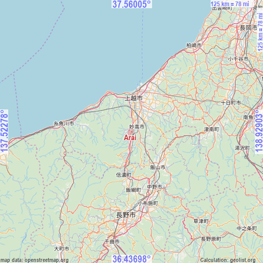
Arai GPS coordinates[2]
37° 0' 2.124" North, 138° 13' 33.24" East
| Map corner | latitude | longitude |
|---|---|---|
| Upper-left | 37.56005°, | 137.52278° |
| Center: | 37.00059°, | 138.2259° |
| Lower-right: | 36.43698°, | 138.92903° |
| Map W x H: | 124.9×124.9 km | = 77.6×77.6mi |
| max Lat: | 45.40944° ⇑18% North |
| Arai: | 37.00059° |
| min Lat: | ⇓82% South 24.34478° |
| min Long | Arai | max Long |
| 123° | 138.2259° | 145.575° |
| W 54.9%⇐ | ⇒45.1% E |
Elevation
Elevation of Arai is 175 m = 574 ft, and this is 90.4 m = 297 ft above average elevation for this country.
| Max E: |
1086 m = 3563 ft | 14.6% |
| Arai | 175 m 574 ft | |
| Avg. | 84.6 m = 278 ft | |
Min E: |
-2 m = -7 ft | 85.4% |
See also: Japan elevation on elevation.city.
Geographical zone
Arai is located in North temperate zone (between Tropic of Cancer and the Arctic Circle). Distance of this Northern Tropic circle is 1508.2 km =937.2 mi to South.| Distance of | km | miles | from Arai |
|---|---|---|---|
| North Pole | 5893 | 3661.7 | to North |
| Arctic Circle | 3287.1 | 2042.5 | to North |
| Tropic Cancer | 1508.2 | 937.2 | to South |
| Equator | 4114.1 | 2556.4 | to South |


Nearby cities:
15 places around Arai: (largest is in red/bold)
• Chikuma
54 km =33.6 mi,  193°
193°
• Hakuba
46.7 km =29 mi,  223°
223°
• Iiyama
20.9 km =13 mi,  143°
143°
• Itoigawa
33.6 km =20.9 mi,  276°
276°
• Jōetsu
16.4 km =10.2 mi,  3°
3°
• Kashiwazaki
49.8 km =30.9 mi,  35°
35°
• Minamiuonuma
58.2 km =36.2 mi,  80°
80°
• Muikamachi
58.8 km =36.5 mi, 82°
• Myoko
4.5 km =2.8 mi,  69°
69°
• Nagano
39.2 km =24.4 mi, 185°
• Nakano
30.5 km =19 mi,  155°
155°
• Ojiya
60.8 km =37.8 mi,  56°
56°
• Shiozawa
55.4 km =34.4 mi,  85°
85°
• Suzaka
39.8 km =24.7 mi,  168°
168°
• Tōkamachi
50.2 km =31.2 mi, 72°
Sources, notices
• [Note1] Compared only with cities in Japan existing in our database
• [Src1] Map data: © OpenStreetMap contributors (CC-BY-SA)
• [Src2] Other city data from geonames.org with taken over terms of usage.
• [Src3] Geographical zone / Annual Mean Temperature by Robert A. Rohde @ Wikipedia
