Kashima-shi geodata
Kashima-shi (Ibaraki) is a seat of a second-order administrative division; located in Japan in Asia/Tokyo (GMT+9) time zone. With population of 65,814 people, there are 297 cities with bigger population in this country. Compared to other cities in Japan, 66.5% of cities are located further ↓South; 89.4% of cities are located further ←West and 56.8% of cities have lower elevation than Kashima-shi. Note1


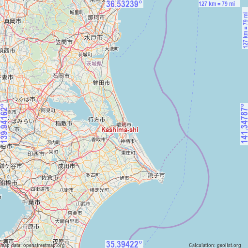
Kashima-shi GPS coordinates[2]
35° 57' 55.296" North, 140° 38' 41.064" East
| Map corner | latitude | longitude |
|---|---|---|
| Upper-left | 36.53239°, | 139.94162° |
| Center: | 35.96536°, | 140.64474° |
| Lower-right: | 35.39422°, | 141.34787° |
| Map W x H: | 126.6×126.6 km | = 78.7×78.7mi |
| max Lat: | 45.40944° ⇑33.5% North |
| Kashima-shi: | 35.96536° |
| min Lat: | ⇓66.5% South 24.34478° |
| min Long | Kashima-shi | max Long |
| 123° | 140.64474° | 145.575° |
| W 89.4%⇐ | ⇒10.6% E |
Elevation
Elevation of Kashima-shi is 38 m = 125 ft, and this is 46.6 m = 153 ft below average elevation for this country.
| Max E: |
1086 m = 3563 ft | 43.2% |
| Avg. | 84.6 m = 278 ft | |
| Kashima-shi | 38 m = 125 ft | |
Min E: |
-2 m = -7 ft | 56.8% |
See also: Kashima-shi elevation on elevation.city.
Geographical zone
Kashima-shi is located in North temperate zone (between Tropic of Cancer and the Arctic Circle). Distance of this Northern Tropic circle is 1393.1 km =865.6 mi to South.| Distance of | km | miles | from Kashima-shi |
|---|---|---|---|
| North Pole | 6008.1 | 3733.3 | to North |
| Arctic Circle | 3402.2 | 2114 | to North |
| Tropic Cancer | 1393.1 | 865.6 | to South |
| Equator | 3999 | 2484.9 | to South |


Nearby cities:
15 places around Kashima-shi: (largest is in red/bold)
• Asahi
27.7 km =17.2 mi,  179°
179°
• Choshi
30.9 km =19.2 mi,  146°
146°
• Edosaki
29.6 km =18.4 mi,  266°
266°
• Hasaki
30.9 km =19.2 mi, 146°
• Hokota
23.5 km =14.6 mi,  330°
330°
• Inashiki
28.9 km =18 mi, 268°
• Itako
9.2 km =5.7 mi,  247°
247°
• Kamisu
7.9 km =4.9 mi,  165°
165°
• Katori-shi
15.1 km =9.4 mi,  240°
240°
• Namegata
14.1 km =8.8 mi,  289°
289°
• Omigawa
13.1 km =8.1 mi,  191°
191°
• Sawara
15.9 km =9.9 mi, 235°
• Sōsa
29 km =18 mi,  196°
196°
• Tomisato
32.7 km =20.3 mi,  221°
221°
• Yōkaichiba
30.7 km =19.1 mi, 196°
Sources, notices
• [Note1] Compared only with cities in Japan existing in our database
• [Src1] Map data: © OpenStreetMap contributors (CC-BY-SA)
• [Src2] Other city data from geonames.org with taken over terms of usage.
• [Src3] Geographical zone / Annual Mean Temperature by Robert A. Rohde @ Wikipedia
