Itako geodata
Itako (Ibaraki) is a seat of a second-order administrative division; located in Japan in Asia/Tokyo (GMT+9) time zone. With population of 25,791 people, there are 600 cities with bigger population in this country. Compared to other cities in Japan, 65.6% of cities are located further ↓South; 87.8% of cities are located further ←West and 99.3% of cities have higher elevation than Itako. Note1


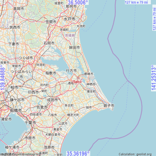
Itako GPS coordinates[2]
35° 55' 59.988" North, 140° 33' 0" East
| Map corner | latitude | longitude |
|---|---|---|
| Upper-left | 36.5006°, | 139.84688° |
| Center: | 35.93333°, | 140.55° |
| Lower-right: | 35.36196°, | 141.25313° |
| Map W x H: | 126.6×126.6 km | = 78.7×78.7mi |
| max Lat: | 45.40944° ⇑34.4% North |
| Itako: | 35.93333° |
| min Lat: | ⇓65.6% South 24.34478° |
| min Long | Itako | max Long |
| 123° | 140.55° | 145.575° |
| W 87.8%⇐ | ⇒12.2% E |
Elevation
Elevation of Itako is 0 m = 0 ft, and this is 84.6 m = 278 ft below average elevation for this country.
| Max E: |
1086 m = 3563 ft | 99.3% |
| Avg. | 84.6 m = 278 ft | |
| Itako | 0 m = 0 ft | |
Min E: |
-2 m = -7 ft | 0.7% |
See also: Japan elevation on elevation.city.
Geographical zone
Itako is located in North temperate zone (between Tropic of Cancer and the Arctic Circle). Distance of this Northern Tropic circle is 1389.5 km =863.4 mi to South.| Distance of | km | miles | from Itako |
|---|---|---|---|
| North Pole | 6011.7 | 3735.5 | to North |
| Arctic Circle | 3405.8 | 2116.3 | to North |
| Tropic Cancer | 1389.5 | 863.4 | to South |
| Equator | 3995.4 | 2482.6 | to South |


Nearby cities:
15 places around Itako: (largest is in red/bold)
• Asahi
25.7 km =16 mi,  159°
159°
• Edosaki
21.1 km =13.1 mi,  275°
275°
• Hokota
24.3 km =15.1 mi,  352°
352°
• Inashiki
20.5 km =12.7 mi, 277°
• Kamisu
11.3 km =7 mi,  111°
111°
• Kashima-shi
9.2 km =5.7 mi,  67°
67°
• Katori-shi
6 km =3.7 mi,  228°
228°
• Namegata
9.5 km =5.9 mi,  329°
329°
• Narita
26.8 km =16.7 mi, 231°
• Omigawa
11 km =6.8 mi,  147°
147°
• Ryūgasaki
33.2 km =20.6 mi,  263°
263°
• Sawara
7.2 km =4.5 mi,  219°
219°
• Sōsa
24.2 km =15 mi,  179°
179°
• Tomisato
24.8 km =15.4 mi,  212°
212°
• Yōkaichiba
25.9 km =16.1 mi, 180°
Sources, notices
• [Note1] Compared only with cities in Japan existing in our database
• [Src1] Map data: © OpenStreetMap contributors (CC-BY-SA)
• [Src2] Other city data from geonames.org with taken over terms of usage.
• [Src3] Geographical zone / Annual Mean Temperature by Robert A. Rohde @ Wikipedia
