Hokota geodata
Hokota (Ibaraki) is a seat of a second-order administrative division; located in Japan in Asia/Tokyo (GMT+9) time zone. In our database, there are 767 cities with bigger population. Compared to other cities in Japan, 70.6% of cities are located further ↓South; 87.4% of cities are located further ←West and 93.5% of cities have higher elevation than Hokota. Note1


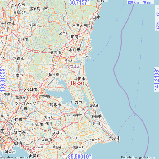
Hokota GPS coordinates[2]
36° 9' 0" North, 140° 31' 0.012" East
| Map corner | latitude | longitude |
|---|---|---|
| Upper-left | 36.7157°, | 139.81355° |
| Center: | 36.15°, | 140.51667° |
| Lower-right: | 35.58019°, | 141.2198° |
| Map W x H: | 126.3×126.3 km | = 78.5×78.5mi |
| max Lat: | 45.40944° ⇑29.4% North |
| Hokota: | 36.15° |
| min Lat: | ⇓70.6% South 24.34478° |
| min Long | Hokota | max Long |
| 123° | 140.51667° | 145.575° |
| W 87.4%⇐ | ⇒12.6% E |
Elevation
Elevation of Hokota is 4 m = 13 ft, and this is 80.6 m = 264 ft below average elevation for this country.
| Max E: |
1086 m = 3563 ft | 93.5% |
| Avg. | 84.6 m = 278 ft | |
| Hokota | 4 m = 13 ft | |
Min E: |
-2 m = -7 ft | 6.5% |
See also: Japan elevation on elevation.city.
Geographical zone
Hokota is located in North temperate zone (between Tropic of Cancer and the Arctic Circle). Distance of this Northern Tropic circle is 1413.6 km =878.4 mi to South.| Distance of | km | miles | from Hokota |
|---|---|---|---|
| North Pole | 5987.6 | 3720.5 | to North |
| Arctic Circle | 3381.7 | 2101.3 | to North |
| Tropic Cancer | 1413.6 | 878.4 | to South |
| Equator | 4019.5 | 2497.6 | to South |


Nearby cities:
15 places around Hokota: (largest is in red/bold)
• Edosaki
28.6 km =17.8 mi,  218°
218°
• Hitachi-Naka
27.5 km =17.1 mi,  3°
3°
• Inashiki
27.7 km =17.2 mi, 218°
• Ishioka
22.7 km =14.1 mi,  279°
279°
• Itako
24.3 km =15.1 mi,  172°
172°
• Kashima-shi
23.5 km =14.6 mi,  150°
150°
• Kasumigaura
24.3 km =15.1 mi,  270°
270°
• Katori-shi
28.1 km =17.5 mi,  183°
183°
• Katsuta
26 km =16.2 mi, 3°
• Mito
23 km =14.3 mi,  344°
344°
• Namegata
16 km =9.9 mi,  186°
186°
• Okunoya
17.3 km =10.7 mi,  328°
328°
• Omitama
16.9 km =10.5 mi,  313°
313°
• Tsuchiura
28.3 km =17.6 mi,  256°
256°
• Ōarai
19.2 km =11.9 mi,  18°
18°
Sources, notices
• [Note1] Compared only with cities in Japan existing in our database
• [Src1] Map data: © OpenStreetMap contributors (CC-BY-SA)
• [Src2] Other city data from geonames.org with taken over terms of usage.
• [Src3] Geographical zone / Annual Mean Temperature by Robert A. Rohde @ Wikipedia
