Choshi geodata
Choshi (Chiba) is a seat of a second-order administrative division; located in Japan in Asia/Tokyo (GMT+9) time zone. In our database, there are 767 cities with bigger population. Compared to other cities in Japan, 60% of cities are located further ↓South; 91.2% of cities are located further ←West and 89.6% of cities have higher elevation than Choshi. Note1


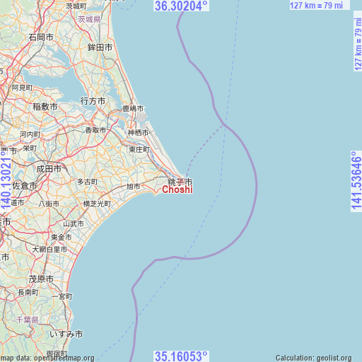
Choshi GPS coordinates[2]
35° 43' 59.988" North, 140° 49' 59.988" East
| Map corner | latitude | longitude |
|---|---|---|
| Upper-left | 36.30204°, | 140.13021° |
| Center: | 35.73333°, | 140.83333° |
| Lower-right: | 35.16053°, | 141.53646° |
| Map W x H: | 126.9×126.9 km | = 78.9×78.9mi |
| max Lat: | 45.40944° ⇑40% North |
| Choshi: | 35.73333° |
| min Lat: | ⇓60% South 24.34478° |
| min Long | Choshi | max Long |
| 123° | 140.83333° | 145.575° |
| W 91.2%⇐ | ⇒8.8% E |
Elevation
Elevation of Choshi is 5 m = 16 ft, and this is 79.6 m = 261 ft below average elevation for this country.
| Max E: |
1086 m = 3563 ft | 89.6% |
| Avg. | 84.6 m = 278 ft | |
| Choshi | 5 m = 16 ft | |
Min E: |
-2 m = -7 ft | 10.4% |
See also: Japan elevation on elevation.city.
Geographical zone
Choshi is located in North temperate zone (between Tropic of Cancer and the Arctic Circle). Distance of this Northern Tropic circle is 1367.3 km =849.6 mi to South.| Distance of | km | miles | from Choshi |
|---|---|---|---|
| North Pole | 6033.9 | 3749.3 | to North |
| Arctic Circle | 3428 | 2130.1 | to North |
| Tropic Cancer | 1367.3 | 849.6 | to South |
| Equator | 3973.2 | 2468.8 | to South |


Nearby cities:
15 places around Choshi: (largest is in red/bold)
• Asahi
16.7 km =10.4 mi,  263°
263°
• Hasaki
0 km =0 mi,  0°
0°
• Itako
33.9 km =21.1 mi,  311°
311°
• Kamisu
23.6 km =14.7 mi,  320°
320°
• Kashima-shi
30.9 km =19.2 mi,  326°
326°
• Katori-shi
35.2 km =21.9 mi,  301°
301°
• Namegata
43 km =26.7 mi, 315°
• Narutō
40.5 km =25.2 mi,  248°
248°
• Omigawa
23.5 km =14.6 mi, 303°
• Sanmu
39.3 km =24.4 mi, 252°
• Sawara
34.4 km =21.4 mi, 299°
• Sōsa
25.4 km =15.8 mi,  265°
265°
• Tomisato
38.8 km =24.1 mi, 271°
• Tōgane
46.8 km =29.1 mi,  244°
244°
• Yōkaichiba
25.8 km =16 mi, 261°
Sources, notices
• [Note1] Compared only with cities in Japan existing in our database
• [Src1] Map data: © OpenStreetMap contributors (CC-BY-SA)
• [Src2] Other city data from geonames.org with taken over terms of usage.
• [Src3] Geographical zone / Annual Mean Temperature by Robert A. Rohde @ Wikipedia
