Uenohara geodata
Uenohara (Yamanashi) is a seat of a second-order administrative division; located in Japan in Asia/Tokyo (GMT+9) time zone. With population of 27,840 people, there are 568 cities with bigger population in this country. Compared to other cities in Japan, 55.4% of cities are located further ↓South; 62.1% of cities are located further ←West and 84.5% of cities have lower elevation than Uenohara. Note1


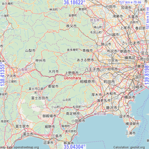
Uenohara GPS coordinates[2]
35° 37' 0.012" North, 139° 7' 0.012" East
| Map corner | latitude | longitude |
|---|---|---|
| Upper-left | 36.18622°, | 138.41355° |
| Center: | 35.61667°, | 139.11667° |
| Lower-right: | 35.04304°, | 139.8198° |
| Map W x H: | 127.1×127.1 km | = 79×79mi |
| max Lat: | 45.40944° ⇑44.6% North |
| Uenohara: | 35.61667° |
| min Lat: | ⇓55.4% South 24.34478° |
| min Long | Uenohara | max Long |
| 123° | 139.11667° | 145.575° |
| W 62.1%⇐ | ⇒37.9% E |
Elevation
Elevation of Uenohara is 165 m = 541 ft, and this is 80.4 m = 264 ft above average elevation for this country.
| Max E: |
1086 m = 3563 ft | 15.5% |
| Uenohara | 165 m 541 ft | |
| Avg. | 84.6 m = 278 ft | |
Min E: |
-2 m = -7 ft | 84.5% |
See also: Japan elevation on elevation.city.
Geographical zone
Uenohara is located in North temperate zone (between Tropic of Cancer and the Arctic Circle). Distance of this Northern Tropic circle is 1354.3 km =841.5 mi to South.| Distance of | km | miles | from Uenohara |
|---|---|---|---|
| North Pole | 6046.9 | 3757.4 | to North |
| Arctic Circle | 3441 | 2138.1 | to North |
| Tropic Cancer | 1354.3 | 841.5 | to South |
| Equator | 3960.2 | 2460.8 | to South |


Nearby cities:
15 places around Uenohara: (largest is in red/bold)
• Akiruno
16.2 km =10.1 mi,  39°
39°
• Akishima
26.5 km =16.5 mi,  64°
64°
• Fussa
23 km =14.3 mi,  54°
54°
• Hachiōji
19.2 km =11.9 mi,  76°
76°
• Hadano
29 km =18 mi,  160°
160°
• Hamura
24.5 km =15.2 mi, 48°
• Hino
26.4 km =16.4 mi, 76°
• Itsukaichi
15.1 km =9.4 mi, 37°
• Sagamihara
12.6 km =7.8 mi,  116°
116°
• Tachikawa
29.2 km =18.1 mi,  69°
69°
• Tsuru
20.3 km =12.6 mi,  247°
247°
• Yamakita
28.4 km =17.6 mi,  186°
186°
• Zama
28.7 km =17.8 mi, 119°
• Ōme
21.8 km =13.5 mi,  31°
31°
• Ōtsuki
12.9 km =8 mi,  270°
270°
Sources, notices
• [Note1] Compared only with cities in Japan existing in our database
• [Src1] Map data: © OpenStreetMap contributors (CC-BY-SA)
• [Src2] Other city data from geonames.org with taken over terms of usage.
• [Src3] Geographical zone / Annual Mean Temperature by Robert A. Rohde @ Wikipedia
