Chino geodata
Chino (Nagano) is a seat of a second-order administrative division; located in Japan in Asia/Tokyo (GMT+9) time zone. With population of 56,567 people, there are 343 cities with bigger population in this country. Compared to other cities in Japan, 67.4% of cities are located further ↓South; 54.3% of cities are located further ←West and 99.7% of cities have lower elevation than Chino. Note1


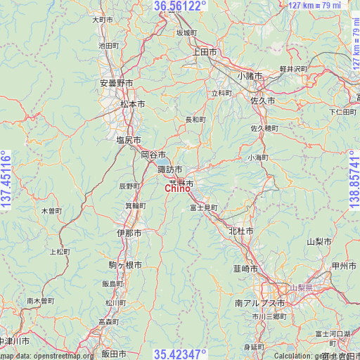
Chino GPS coordinates[2]
35° 59' 39.84" North, 138° 9' 15.408" East
| Map corner | latitude | longitude |
|---|---|---|
| Upper-left | 36.56122°, | 137.45116° |
| Center: | 35.9944°, | 138.15428° |
| Lower-right: | 35.42347°, | 138.85741° |
| Map W x H: | 126.5×126.5 km | = 78.6×78.6mi |
| max Lat: | 45.40944° ⇑32.6% North |
| Chino: | 35.9944° |
| min Lat: | ⇓67.4% South 24.34478° |
| min Long | Chino | max Long |
| 123° | 138.15428° | 145.575° |
| W 54.3%⇐ | ⇒45.7% E |
Elevation
Elevation of Chino is 801 m = 2628 ft, and this is 716.4 m = 2350 ft above average elevation for this country.
| Max E: |
1086 m = 3563 ft | 0.3% |
| Chino | 801 m 2628 ft | |
| Avg. | 84.6 m = 278 ft | |
Min E: |
-2 m = -7 ft | 99.7% |
See also: Chino elevation on elevation.city.
Geographical zone
Chino is located in North temperate zone (between Tropic of Cancer and the Arctic Circle). Distance of this Northern Tropic circle is 1396.3 km =867.6 mi to South.| Distance of | km | miles | from Chino |
|---|---|---|---|
| North Pole | 6004.9 | 3731.3 | to North |
| Arctic Circle | 3399 | 2112 | to North |
| Tropic Cancer | 1396.3 | 867.6 | to South |
| Equator | 4002.2 | 2486.9 | to South |


Nearby cities:
15 places around Chino: (largest is in red/bold)
• Azumino
40.5 km =25.2 mi,  323°
323°
• Hokuto
28.1 km =17.5 mi,  129°
129°
• Ina
25.9 km =16.1 mi,  224°
224°
• Kamimaruko
37.6 km =23.4 mi,  16°
16°
• Komagane
36.6 km =22.7 mi,  212°
212°
• Komoro
43.7 km =27.2 mi,  34°
34°
• Matsumoto
31.5 km =19.6 mi,  327°
327°
• Nirasaki
42.2 km =26.2 mi,  140°
140°
• Okaya
12 km =7.5 mi,  305°
305°
• Saku
38.5 km =23.9 mi,  50°
50°
• Shiojiri
20.6 km =12.8 mi,  304°
304°
• Suwa
6.1 km =3.8 mi, 322°
• Tatsuno
14.2 km =8.8 mi,  265°
265°
• Toyoshina
40.9 km =25.4 mi, 326°
• Tōmi
44.3 km =27.5 mi, 24°
Sources, notices
• [Note1] Compared only with cities in Japan existing in our database
• [Src1] Map data: © OpenStreetMap contributors (CC-BY-SA)
• [Src2] Other city data from geonames.org with taken over terms of usage.
• [Src3] Geographical zone / Annual Mean Temperature by Robert A. Rohde @ Wikipedia
