Hirado geodata
Hirado (Nagasaki) is a seat of a second-order administrative division; located in Japan in Asia/Tokyo (GMT+9) time zone. With population of 22,516 people, there are 650 cities with bigger population in this country. Compared to other cities in Japan, 87% of cities are located further ↑North; 98% of cities are located further →East and 89.6% of cities have higher elevation than Hirado. Note1


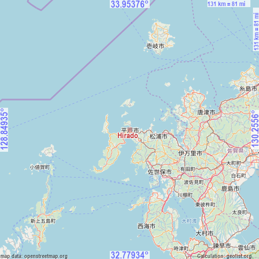
Hirado GPS coordinates[2]
33° 22' 6.708" North, 129° 33' 8.892" East
| Map corner | latitude | longitude |
|---|---|---|
| Upper-left | 33.95376°, | 128.84935° |
| Center: | 33.36853°, | 129.55247° |
| Lower-right: | 32.77934°, | 130.2556° |
| Map W x H: | 130.6×130.6 km | = 81.2×81.2mi |
| max Lat: | 45.40944° ⇑87% North |
| Hirado: | 33.36853° |
| min Lat: | ⇓13% South 24.34478° |
| min Long | Hirado | max Long |
| 123° | 129.55247° | 145.575° |
| W 2%⇐ | ⇒98% E |
Elevation
Elevation of Hirado is 5 m = 16 ft, and this is 79.6 m = 261 ft below average elevation for this country.
| Max E: |
1086 m = 3563 ft | 89.6% |
| Avg. | 84.6 m = 278 ft | |
| Hirado | 5 m = 16 ft | |
Min E: |
-2 m = -7 ft | 10.4% |
See also: Japan elevation on elevation.city.
Geographical zone
Hirado is located in North temperate zone (between Tropic of Cancer and the Arctic Circle). Distance of this Northern Tropic circle is 1104.3 km =686.2 mi to South.| Distance of | km | miles | from Hirado |
|---|---|---|---|
| North Pole | 6296.8 | 3912.6 | to North |
| Arctic Circle | 3690.9 | 2293.4 | to North |
| Tropic Cancer | 1104.3 | 686.2 | to South |
| Equator | 3710.2 | 2305.4 | to South |


Nearby cities:
15 places around Hirado: (largest is in red/bold)
• Iki
48.6 km =30.2 mi,  18°
18°
• Imari
32.5 km =20.2 mi,  105°
105°
• Imarichō-kō
32.1 km =19.9 mi, 109°
• Itoshima
61.7 km =38.3 mi,  71°
71°
• Karatsu
39.6 km =24.6 mi,  78°
78°
• Kashima
57.9 km =36 mi,  120°
120°
• Matsuura
13.6 km =8.5 mi,  103°
103°
• Ogi
60.5 km =37.6 mi, 99°
• Saikai
44.4 km =27.6 mi,  164°
164°
• Sasebo
27.4 km =17 mi,  144°
144°
• Takeo
47.1 km =29.3 mi, 114°
• Takeochō-takeo
47.8 km =29.7 mi, 114°
• Taku
52.7 km =32.7 mi, 101°
• Ureshino
53.6 km =33.3 mi, 118°
• Ureshinomachi-shimojuku
50.6 km =31.4 mi, 124°
Sources, notices
• [Note1] Compared only with cities in Japan existing in our database
• [Src1] Map data: © OpenStreetMap contributors (CC-BY-SA)
• [Src2] Other city data from geonames.org with taken over terms of usage.
• [Src3] Geographical zone / Annual Mean Temperature by Robert A. Rohde @ Wikipedia
