Matsuura geodata
Matsuura (Nagasaki) is a seat of a second-order administrative division; located in Japan in Asia/Tokyo (GMT+9) time zone. In our database, there are 767 cities with bigger population. Compared to other cities in Japan, 87.3% of cities are located further ↑North; 97.8% of cities are located further →East and 78.4% of cities have lower elevation than Matsuura. Note1


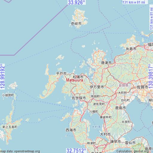
Matsuura GPS coordinates[2]
33° 20' 26.088" North, 129° 41' 42.144" East
| Map corner | latitude | longitude |
|---|---|---|
| Upper-left | 33.926°, | 128.99192° |
| Center: | 33.34058°, | 129.69504° |
| Lower-right: | 32.7512°, | 130.39817° |
| Map W x H: | 130.6×130.6 km | = 81.2×81.2mi |
| max Lat: | 45.40944° ⇑87.3% North |
| Matsuura: | 33.34058° |
| min Lat: | ⇓12.7% South 24.34478° |
| min Long | Matsuura | max Long |
| 123° | 129.69504° | 145.575° |
| W 2.2%⇐ | ⇒97.8% E |
Elevation
Elevation of Matsuura is 110 m = 361 ft, and this is 25.4 m = 83 ft above average elevation for this country.
| Max E: |
1086 m = 3563 ft | 21.6% |
| Matsuura | 110 m 361 ft | |
| Avg. | 84.6 m = 278 ft | |
Min E: |
-2 m = -7 ft | 78.4% |
See also: Japan elevation on elevation.city.
Geographical zone
Matsuura is located in North temperate zone (between Tropic of Cancer and the Arctic Circle). Distance of this Northern Tropic circle is 1101.2 km =684.3 mi to South.| Distance of | km | miles | from Matsuura |
|---|---|---|---|
| North Pole | 6299.9 | 3914.6 | to North |
| Arctic Circle | 3694 | 2295.3 | to North |
| Tropic Cancer | 1101.2 | 684.3 | to South |
| Equator | 3707.1 | 2303.5 | to South |


Nearby cities:
15 places around Matsuura: (largest is in red/bold)
• Hirado
13.6 km =8.5 mi,  283°
283°
• Iki
49.2 km =30.6 mi,  2°
2°
• Imari
19 km =11.8 mi,  107°
107°
• Imarichō-kō
18.6 km =11.6 mi, 113°
• Itoshima
50.6 km =31.4 mi,  63°
63°
• Karatsu
27.9 km =17.3 mi,  66°
66°
• Kashima
45.1 km =28 mi,  125°
125°
• Ogi
46.9 km =29.1 mi,  98°
98°
• Saikai
39.7 km =24.7 mi,  181°
181°
• Sasebo
19.4 km =12.1 mi,  171°
171°
• Takeo
33.9 km =21.1 mi,  119°
119°
• Takeochō-takeo
34.6 km =21.5 mi, 118°
• Taku
39.1 km =24.3 mi, 100°
• Ureshino
40.7 km =25.3 mi, 124°
• Ureshinomachi-shimojuku
38.2 km =23.7 mi, 131°
Sources, notices
• [Note1] Compared only with cities in Japan existing in our database
• [Src1] Map data: © OpenStreetMap contributors (CC-BY-SA)
• [Src2] Other city data from geonames.org with taken over terms of usage.
• [Src3] Geographical zone / Annual Mean Temperature by Robert A. Rohde @ Wikipedia
