Saikai geodata
Saikai (Nagasaki) is a seat of a second-order administrative division; located in Japan in Asia/Tokyo (GMT+9) time zone. In our database, there are 767 cities with bigger population. Compared to other cities in Japan, 90.7% of cities are located further ↑North; 97.9% of cities are located further →East and 86.5% of cities have lower elevation than Saikai. Note1


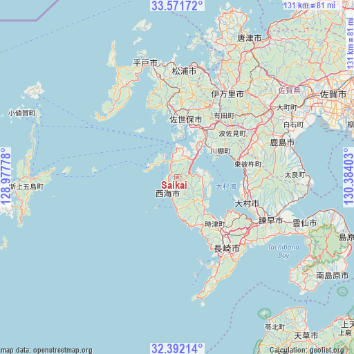
Saikai GPS coordinates[2]
32° 59' 2.04" North, 129° 40' 51.24" East
| Map corner | latitude | longitude |
|---|---|---|
| Upper-left | 33.57172°, | 128.97778° |
| Center: | 32.9839°, | 129.6809° |
| Lower-right: | 32.39214°, | 130.38403° |
| Map W x H: | 131.2×131.2 km | = 81.5×81.5mi |
| max Lat: | 45.40944° ⇑90.7% North |
| Saikai: | 32.9839° |
| min Lat: | ⇓9.3% South 24.34478° |
| min Long | Saikai | max Long |
| 123° | 129.6809° | 145.575° |
| W 2.1%⇐ | ⇒97.9% E |
Elevation
Elevation of Saikai is 184 m = 604 ft, and this is 99.4 m = 326 ft above average elevation for this country.
| Max E: |
1086 m = 3563 ft | 13.5% |
| Saikai | 184 m 604 ft | |
| Avg. | 84.6 m = 278 ft | |
Min E: |
-2 m = -7 ft | 86.5% |
See also: Japan elevation on elevation.city.
Geographical zone
Saikai is located in North temperate zone (between Tropic of Cancer and the Arctic Circle). Distance of this Northern Tropic circle is 1061.5 km =659.6 mi to South.| Distance of | km | miles | from Saikai |
|---|---|---|---|
| North Pole | 6339.6 | 3939.2 | to North |
| Arctic Circle | 3733.7 | 2320 | to North |
| Tropic Cancer | 1061.5 | 659.6 | to South |
| Equator | 3667.5 | 2278.9 | to South |


Nearby cities:
15 places around Saikai: (largest is in red/bold)
• Hirado
44.4 km =27.6 mi,  344°
344°
• Imari
39.2 km =24.4 mi,  29°
29°
• Imarichō-kō
37.1 km =23.1 mi, 29°
• Isahaya
37.3 km =23.2 mi,  115°
115°
• Kashima
40.5 km =25.2 mi,  70°
70°
• Matsuura
39.7 km =24.7 mi,  1°
1°
• Nagasaki
32.2 km =20 mi,  143°
143°
• Obita
26.5 km =16.5 mi,  134°
134°
• Sasebo
20.9 km =13 mi,  11°
11°
• Takeo
38.6 km =24 mi,  53°
53°
• Takeochō-takeo
39.1 km =24.3 mi, 54°
• Togitsu
23 km =14.3 mi, 136°
• Ureshino
38.9 km =24.2 mi,  64°
64°
• Ureshinomachi-shimojuku
33.3 km =20.7 mi, 64°
• Ōmura
26.4 km =16.4 mi,  105°
105°
Sources, notices
• [Note1] Compared only with cities in Japan existing in our database
• [Src1] Map data: © OpenStreetMap contributors (CC-BY-SA)
• [Src2] Other city data from geonames.org with taken over terms of usage.
• [Src3] Geographical zone / Annual Mean Temperature by Robert A. Rohde @ Wikipedia
