Komagane geodata
Komagane (Nagano) is a seat of a second-order administrative division; located in Japan in Asia/Tokyo (GMT+9) time zone. In our database, there are 767 cities with bigger population. Compared to other cities in Japan, 58.8% of cities are located further ↓South; 53.2% of cities are located further ←West and 98.3% of cities have lower elevation than Komagane. Note1


Komagane GPS coordinates[2]
35° 42' 59.652" North, 137° 56' 14.82" East
| Map corner | latitude | longitude |
|---|---|---|
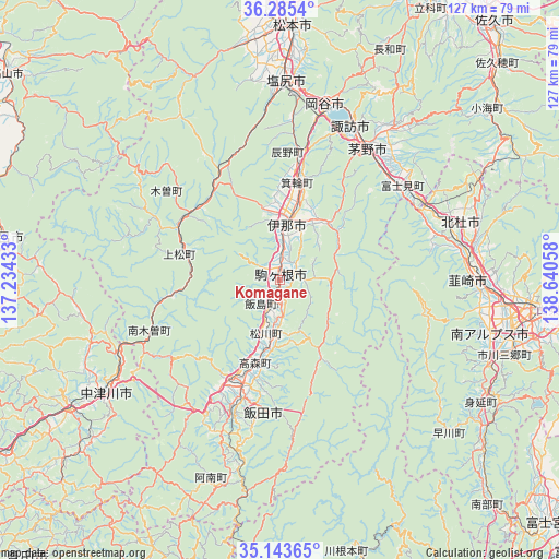
| Upper-left | 36.2854°, | 137.23433° |
| Center: | 35.71657°, | 137.93745° |
| Lower-right: | 35.14365°, | 138.64058° |
| Map W x H: | 127×127 km | = 78.9×78.9mi |
| max Lat: | 45.40944° ⇑41.2% North |
| Komagane: | 35.71657° |
| min Lat: | ⇓58.8% South 24.34478° |
| min Long | Komagane | max Long |
| 123° | 137.93745° | 145.575° |
| W 53.2%⇐ | ⇒46.8% E |
Elevation
Elevation of Komagane is 640 m = 2100 ft, and this is 555.4 m = 1822 ft above average elevation for this country.
| Max E: |
1086 m = 3563 ft | 1.7% |
| Komagane | 640 m 2100 ft | |
| Avg. | 84.6 m = 278 ft | |
Min E: |
-2 m = -7 ft | 98.3% |
See also: Japan elevation on elevation.city.
Geographical zone
Komagane is located in North temperate zone (between Tropic of Cancer and the Arctic Circle). Distance of this Northern Tropic circle is 1365.4 km =848.4 mi to South.| Distance of | km | miles | from Komagane |
|---|---|---|---|
| North Pole | 6035.8 | 3750.5 | to North |
| Arctic Circle | 3429.9 | 2131.2 | to North |
| Tropic Cancer | 1365.4 | 848.4 | to South |
| Equator | 3971.3 | 2467.7 | to South |


Nearby cities:
15 places around Komagane: (largest is in red/bold)
• Chino
36.6 km =22.7 mi,  32°
32°
• Chūō
52.8 km =32.8 mi,  104°
104°
• Hokuto
43.4 km =27 mi,  72°
72°
• Iida
24.3 km =15.1 mi,  205°
205°
• Ina
12.4 km =7.7 mi,  6°
6°
• Kai
51.8 km =32.2 mi,  93°
93°
• Kōfu
57.1 km =35.5 mi, 95°
• Minami-Alps
48.8 km =30.3 mi, 103°
• Nakatsugawa
47.3 km =29.4 mi,  236°
236°
• Nirasaki
46.3 km =28.8 mi, 92°
• Okaya
39 km =24.2 mi, 14°
• Ryūō
51.3 km =31.9 mi, 98°
• Shiojiri
42.7 km =26.5 mi,  3°
3°
• Suwa
39.1 km =24.3 mi,  23°
23°
• Tatsuno
30.2 km =18.8 mi, 10°
Sources, notices
• [Note1] Compared only with cities in Japan existing in our database
• [Src1] Map data: © OpenStreetMap contributors (CC-BY-SA)
• [Src2] Other city data from geonames.org with taken over terms of usage.
• [Src3] Geographical zone / Annual Mean Temperature by Robert A. Rohde @ Wikipedia
