Kimitsu geodata
Kimitsu (Chiba) is a seat of a second-order administrative division; located in Japan in Asia/Tokyo (GMT+9) time zone. With population of 92,126 people, there are 219 cities with bigger population in this country. Compared to other cities in Japan, 50.4% of cities are located further ↑North; 75.9% of cities are located further ←West and 93.5% of cities have higher elevation than Kimitsu. Note1


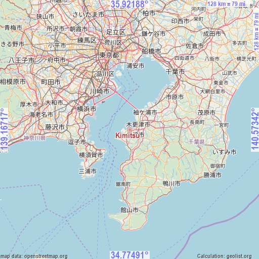
Kimitsu GPS coordinates[2]
35° 21' 1.548" North, 139° 52' 13.044" East
| Map corner | latitude | longitude |
|---|---|---|
| Upper-left | 35.92188°, | 139.16717° |
| Center: | 35.35043°, | 139.87029° |
| Lower-right: | 34.77491°, | 140.57342° |
| Map W x H: | 127.5×127.5 km | = 79.2×79.2mi |
| max Lat: | 45.40944° ⇑50.4% North |
| Kimitsu: | 35.35043° |
| min Lat: | ⇓49.6% South 24.34478° |
| min Long | Kimitsu | max Long |
| 123° | 139.87029° | 145.575° |
| W 75.9%⇐ | ⇒24.1% E |
Elevation
Elevation of Kimitsu is 4 m = 13 ft, and this is 80.6 m = 264 ft below average elevation for this country.
| Max E: |
1086 m = 3563 ft | 93.5% |
| Avg. | 84.6 m = 278 ft | |
| Kimitsu | 4 m = 13 ft | |
Min E: |
-2 m = -7 ft | 6.5% |
See also: Kimitsu elevation on elevation.city.
Geographical zone
Kimitsu is located in North temperate zone (between Tropic of Cancer and the Arctic Circle). Distance of this Northern Tropic circle is 1324.7 km =823.1 mi to South.| Distance of | km | miles | from Kimitsu |
|---|---|---|---|
| North Pole | 6076.5 | 3775.8 | to North |
| Arctic Circle | 3470.6 | 2156.5 | to North |
| Tropic Cancer | 1324.7 | 823.1 | to South |
| Equator | 3930.6 | 2442.4 | to South |


Nearby cities:
15 places around Kimitsu: (largest is in red/bold)
• Chiba
35.6 km =22.1 mi,  38°
38°
• Futtsu
6.4 km =4 mi,  226°
226°
• Hayama
27.8 km =17.3 mi,  252°
252°
• Ichihara
26.7 km =16.6 mi,  46°
46°
• Kamakura
29.4 km =18.3 mi,  260°
260°
• Kamogawa
35.1 km =21.8 mi,  143°
143°
• Kawasaki
23.5 km =14.6 mi,  323°
323°
• Kisarazu
6.7 km =4.2 mi,  57°
57°
• Miura
32.7 km =20.3 mi,  224°
224°
• Sodegaura
15.4 km =9.6 mi, 62°
• Urayasu
32.5 km =20.2 mi,  5°
5°
• Urayasu
35.6 km =22.1 mi,  2°
2°
• Yokohama
22 km =13.7 mi,  294°
294°
• Yokosuka
19.9 km =12.4 mi, 248°
• Zushi
27.2 km =16.9 mi, 256°
Sources, notices
• [Note1] Compared only with cities in Japan existing in our database
• [Src1] Map data: © OpenStreetMap contributors (CC-BY-SA)
• [Src2] Other city data from geonames.org with taken over terms of usage.
• [Src3] Geographical zone / Annual Mean Temperature by Robert A. Rohde @ Wikipedia
