Urayasu geodata
Urayasu (Chiba) is a seat of a second-order administrative division; located in Japan in Asia/Tokyo (GMT+9) time zone. In our database, there are 767 cities with bigger population. Compared to other cities in Japan, 56% of cities are located further ↓South; 76.7% of cities are located further ←West and 79% of cities have higher elevation than Urayasu. Note1


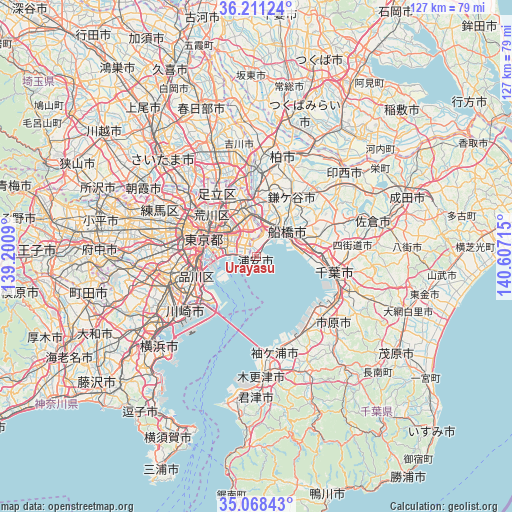
Urayasu GPS coordinates[2]
35° 38' 30.768" North, 139° 54' 14.472" East
| Map corner | latitude | longitude |
|---|---|---|
| Upper-left | 36.21124°, | 139.2009° |
| Center: | 35.64188°, | 139.90402° |
| Lower-right: | 35.06843°, | 140.60715° |
| Map W x H: | 127.1×127.1 km | = 79×79mi |
| max Lat: | 45.40944° ⇑44% North |
| Urayasu: | 35.64188° |
| min Lat: | ⇓56% South 24.34478° |
| min Long | Urayasu | max Long |
| 123° | 139.90402° | 145.575° |
| W 76.7%⇐ | ⇒23.3% E |
Elevation
Elevation of Urayasu is 8 m = 26 ft, and this is 76.6 m = 251 ft below average elevation for this country.
| Max E: |
1086 m = 3563 ft | 79% |
| Avg. | 84.6 m = 278 ft | |
| Urayasu | 8 m = 26 ft | |
Min E: |
-2 m = -7 ft | 21% |
See also: Japan elevation on elevation.city.
Geographical zone
Urayasu is located in North temperate zone (between Tropic of Cancer and the Arctic Circle). Distance of this Northern Tropic circle is 1357.1 km =843.3 mi to South.| Distance of | km | miles | from Urayasu |
|---|---|---|---|
| North Pole | 6044.1 | 3755.6 | to North |
| Arctic Circle | 3438.2 | 2136.4 | to North |
| Tropic Cancer | 1357.1 | 843.3 | to South |
| Equator | 3963 | 2462.5 | to South |


Nearby cities:
15 places around Urayasu: (largest is in red/bold)
• Chiba
19.8 km =12.3 mi,  103°
103°
• Funabashi
13.1 km =8.1 mi,  48°
48°
• Honchō
10 km =6.2 mi, 48°
• Ichihara
21.4 km =13.3 mi,  130°
130°
• Ichikawa-minami
9.4 km =5.8 mi,  359°
359°
• Kamagaya
16.8 km =10.4 mi,  31°
31°
• Kawasaki
21.6 km =13.4 mi,  231°
231°
• Matsudo
15.4 km =9.6 mi, 359°
• Misato
22.5 km =14 mi, 355°
• Narashino
13.2 km =8.2 mi,  70°
70°
• Shiroi
22.9 km =14.2 mi,  39°
39°
• Tokyo
19.9 km =12.4 mi,  285°
285°
• Urayasu
3.5 km =2.2 mi,  336°
336°
• Yachiyo
22.5 km =14 mi,  62°
62°
• Yashio
20.9 km =13 mi, 343°
Sources, notices
• [Note1] Compared only with cities in Japan existing in our database
• [Src1] Map data: © OpenStreetMap contributors (CC-BY-SA)
• [Src2] Other city data from geonames.org with taken over terms of usage.
• [Src3] Geographical zone / Annual Mean Temperature by Robert A. Rohde @ Wikipedia
