Sodegaura geodata
Sodegaura (Chiba) is a seat of a second-order administrative division; located in Japan in Asia/Tokyo (GMT+9) time zone. In our database, there are 767 cities with bigger population. Compared to other cities in Japan, 51% of cities are located further ↓South; 79.2% of cities are located further ←West and 61.1% of cities have higher elevation than Sodegaura. Note1


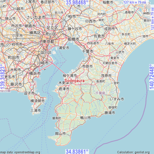
Sodegaura GPS coordinates[2]
35° 24' 49.248" North, 140° 1' 16.86" East
| Map corner | latitude | longitude |
|---|---|---|
| Upper-left | 35.98468°, | 139.31823° |
| Center: | 35.41368°, | 140.02135° |
| Lower-right: | 34.83861°, | 140.72448° |
| Map W x H: | 127.4×127.4 km | = 79.2×79.2mi |
| max Lat: | 45.40944° ⇑49% North |
| Sodegaura: | 35.41368° |
| min Lat: | ⇓51% South 24.34478° |
| min Long | Sodegaura | max Long |
| 123° | 140.02135° | 145.575° |
| W 79.2%⇐ | ⇒20.8% E |
Elevation
Elevation of Sodegaura is 18 m = 59 ft, and this is 66.6 m = 219 ft below average elevation for this country.
| Max E: |
1086 m = 3563 ft | 61.1% |
| Avg. | 84.6 m = 278 ft | |
| Sodegaura | 18 m = 59 ft | |
Min E: |
-2 m = -7 ft | 38.9% |
See also: Japan elevation on elevation.city.
Geographical zone
Sodegaura is located in North temperate zone (between Tropic of Cancer and the Arctic Circle). Distance of this Northern Tropic circle is 1331.7 km =827.5 mi to South.| Distance of | km | miles | from Sodegaura |
|---|---|---|---|
| North Pole | 6069.4 | 3771.3 | to North |
| Arctic Circle | 3463.5 | 2152.1 | to North |
| Tropic Cancer | 1331.7 | 827.5 | to South |
| Equator | 3937.6 | 2446.7 | to South |


Nearby cities:
15 places around Sodegaura: (largest is in red/bold)
• Chiba
22.4 km =13.9 mi,  22°
22°
• Futtsu
21.6 km =13.4 mi,  238°
238°
• Honchō
32.1 km =19.9 mi,  354°
354°
• Ichihara
12.8 km =8 mi,  26°
26°
• Kawasaki
30 km =18.6 mi,  293°
293°
• Kimitsu
15.4 km =9.6 mi, 242°
• Kisarazu
8.7 km =5.4 mi,  247°
247°
• Mobara
24.9 km =15.5 mi,  86°
86°
• Narashino
29.9 km =18.6 mi,  3°
3°
• Urayasu
27.5 km =17.1 mi,  337°
337°
• Urayasu
31 km =19.3 mi, 337°
• Yokohama
33.7 km =20.9 mi,  273°
273°
• Yotsukaidō
29.4 km =18.3 mi, 26°
• Ōami
29.1 km =18.1 mi,  66°
66°
• Ōamishirasato
31.9 km =19.8 mi, 70°
Sources, notices
• [Note1] Compared only with cities in Japan existing in our database
• [Src1] Map data: © OpenStreetMap contributors (CC-BY-SA)
• [Src2] Other city data from geonames.org with taken over terms of usage.
• [Src3] Geographical zone / Annual Mean Temperature by Robert A. Rohde @ Wikipedia
